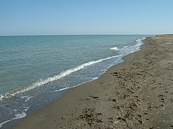
Uvs Lake
| Uvs Lake | |
|---|---|
 |
|
| Coordinates | 50°18′N 92°42′E / 50.300°N 92.700°ECoordinates: 50°18′N 92°42′E / 50.300°N 92.700°E |
| Type | saline |
| Primary inflows | Tesiin gol and others |
| Primary outflows | none |
| Basin countries | Mongolia, Russia |
| Max. length | 84 km (52 mi) |
| Max. width | 79 km (49 mi) |
| Surface area | 3,350 km2 (1,290 sq mi) |
| Average depth | 6 m (20 ft) |
| Surface elevation | 759 m (2,490 ft) |
| Settlements | Ulaangom |
| Designated | 22 March 2004 |
Uvs Lake (Mongolian: Увс нуур, Uws núr; Russian: озеро Убсу-Нур, ozero Ubsu-Nur, Ubsu-Nur lake) is a highly saline lake in an endorheic basin - Uvs Nuur Basin in Mongolia with a small part in Russia. It is the largest lake in Mongolia by surface area, covering 3,350 km² at 759 m above sea level. The northeastern tip of the lake is situated in the Tuva Republic of the Russian Federation. The largest settlement near the lake is Ulaangom. This shallow and very saline body of water is a remainder of a huge saline sea which covered a much larger area several thousand years ago.
The name Uvs Nuur (sometimes spelled Ubsa Nor or Ubsunur) derives from subsen, a Mongolian word referring to the bitter dregs left behind in the making of airag (Mongolian milk wine), and nuur, the Mongolian word for lake. The name is a reference to the lake's salty, undrinkable water.
Uvs Lake has a length of 84 km and a width of 79 km, with an average depth of 6 m. Its basin is separated from the rest of the Great Lakes Depression by the Khan Khökhii ridge. However, it is not a rift lake as some mistakenly think.
The main feeding rivers are the Baruunturuun, Nariin gol, and Tes (primary feed of the lake) from Khangai Mountains in the east, and the Kharkhiraa River and Sangil gol from the Altai Mountains in the west.
The very large catchment area with no exit results in highly saline water (18.8 ppt, one half as salty as the oceans), primarily due to sulphate and sodium ions.
...
Wikipedia
