Uturunku
| Uturunku | |
|---|---|

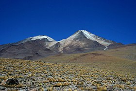
Uturunku in Bolivia, 16 November 2006
|
|
| Highest point | |
| Elevation | 6,008 metres (19,711 ft) |
| Listing | List of mountains in Bolivia |
| Coordinates | 22°16′12″S 67°10′48″W / 22.27000°S 67.18000°WCoordinates: 22°16′12″S 67°10′48″W / 22.27000°S 67.18000°W |
| Naming | |
| Translation | Jaguar (Quechua) |
| Geography | |
| Location | San Pablo de Lípez Municipality, Sur Lípez Province, Potosí Department, Bolivia |
| Parent range | Cordillera de Lípez |
| Geology | |
| Age of rock | |
| Mountain type | Stratovolcano |
| Volcanic field | Altiplano–Puna volcanic complex |
| Last eruption | 271,000 years ago. |
Uturunku (Quechua for jaguar,Hispanicized spellings Uturunco, Uturuncu) is a dormant volcano in the Cordillera de Lípez in Potosí Department, Bolivia. It is located in the Sur Lípez Province, San Pablo de Lípez Municipality. It is in the Central Volcanic Zone of the Andes, and its highest summit is 6,008 metres (19,711 ft) above sea level. The volcano has two summits, with a fumarole field between them. The volcano's landforms include lava domes and lava flows.
The volcano was sporadically active during the , with the most recent eruption dated at 271,000 years ago. Since then, Uturunku has displayed fumarolic activity. Starting in 1992, satellite observations have indicated a large area of regional uplift centered on Uturunku, which has been interpreted as an indication of large-scale magma intrusion under the volcano. This might be a prelude to large-scale volcanic activity, including "supervolcanic" activity and caldera formation.
Uturunku is a dormant 6,008 metres (19,711 ft) high stratovolcano south of Quetena Chico, in the Altiplano of Bolivia. The edifice has a volume of 85 cubic kilometres (20 cu mi), covering an area of 400 square kilometres (150 sq mi) on a base altitude of 4,500 metres (14,800 ft). It is constructed from porphyritic dacite lava flows and lava domes.Andesitic enclaves are also present and some dacites border on silicic andesite in composition. The edifice has been affected by glacial activity. The and lava flows form the base of the edifice and extend 15 kilometres (9.3 mi) away from the volcano. Middle and lavas form the upper part of the volcanoes and extend up to 10 kilometres (6.2 mi) away. According to geological inspection involving both aerial surveys and field work, the longest lava flows appear to generate from the central vent. Flow features on the lavas are well preserved, and are blocky with high fronts. The flows are several tens of metres thick. A sulfur mine (22°14′50″S 67°10′53″W / 22.24722°S 67.18139°W) was reported in 1975. It was based on native sulfur and minor realgar in the volcanic ash, with an estimated 50,000,000 tonnes (49,000,000 long tons; 55,000,000 short tons) of ore. A road was reported to have existed in 1948-1950, leading from Uyuni over Quetena to Uturunku.Laguna Celeste lies at the foot of the volcano and is fed by snow melt from the volcano's northeastern side. Mama Khumu, a lake on the eastern side of the volcano, is also fed from the volcano. Other lakes include Chojllas on the southeastern foot and Loromayu on the southern side. The Rio Grande de Lipez flows along the western foot of Uturunku. The c. 3 million years old Cerro San Antonio volcano lies north of Uturunku.
...
Wikipedia

