Uttranchal
|
Uttarakhand Uttarākhaṇḍ Rājya |
||
|---|---|---|
| State | ||
|
||
| Nickname(s): Devbhumi | ||
 Location of Uttarakhand in India |
||
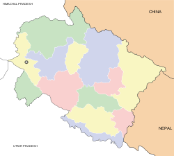
 Map of Uttarakhand |
||
| Coordinates (Dehradun): 30°20′N 78°04′E / 30.33°N 78.06°ECoordinates: 30°20′N 78°04′E / 30.33°N 78.06°E | ||
| Country |
|
|
| Statehood | 9 November 2000 | |
| Capital | Dehradun | |
| Largest city | Dehradun | |
| Districts | 13 | |
| Government | ||
| • Body | Government of Uttarakhand | |
| • Governor | Krishan Kant Paul | |
| • Chief Minister | Trivendra Singh Rawat (BJP) | |
| • Chief Justice | K. M. Joseph | |
| • Speaker of the House | Premchand Aggarwal (BJP) | |
| • Electoral constituencies | ||
| Area | ||
| • Total | 53,483 km2 (20,650 sq mi) | |
| Area rank | 19th | |
| Population (2011) | ||
| • Total | 10,086,292 | |
| • Rank | 20th | |
| • Density | 189/km2 (490/sq mi) | |
| • Density rank | 20th | |
| • Male | 5,137,773 | |
| • Female | 4,948,519 | |
| Demonym(s) | Uttarakhandi | |
| Languages | ||
| • Official | Hindi | |
| • Additional official | Sanskrit | |
| Time zone | IST (UTC+05:30) | |
| ISO 3166 code | IN-UT | |
| Vehicle registration | UK 01—XX | |
| HDI (2011) |
|
|
| • Rank | 7th | |
| Literacy (2011) | 79.63% | |
| • Male | 88.33% | |
| • Female | 70.70% | |
| • Rank | 17th | |
| Sex ratio (2011) | 963 ♀ / 1000 ♂ | |
| • Rank | 13th | |
| Website | uk |
|
|
^a Uttarakhand was formed by the Uttar Pradesh Reorganisation Act, 2000 with the bifurcation of erstwhile Uttar Pradesh on November 9, 2000. ^b Dehradun is the capital of Uttarakhand. The town of Gairsain is envisaged as the state's new capital. ^c 70 seats are open for the direct election while 1 seat is reserved for the member of Anglo Indian community. |
||
| Population Growth | |||
|---|---|---|---|
| Census | Pop. | %± | |
| 1951 | 2,946,000 |
—
|
|
| 1961 | 3,611,000 | 22.6% | |
| 1971 | 4,493,000 | 24.4% | |
| 1981 | 5,726,000 | 27.4% | |
| 1991 | 7,051,000 | 23.1% | |
| 2001 | 8,489,000 | 20.4% | |
| 2011 | 10,086,292 | 18.8% | |
| Source: Census of India | |||
| Animal | Alpine Musk Deer |
|---|---|
| Bird | Himalayan Monal |
| Flower | Brahma Kamal |
| Fruit | Kaphal |
| Tree | Burans |
Uttarakhand (/ˌʊtəˈrɑːkʌnd/), officially Uttarākhaṇḍ Rājya , formerly known as Uttaranchal, is a state in the northern part of India. It is often referred to as the Devbhumi (literally "Land of the Gods") due to many Hindu temples and pilgrimage centres found throughout the state. Uttarakhand is known for the natural environment of the Himalayas, the Bhabhar and the Terai. On 9 November 2000, Uttarakhand became the 27th state of the Republic of India, being created from the Himalayan and adjoining northwestern districts of Uttar Pradesh. It borders Tibet to the north; the Mahakali Zone of the Far-Western Region, Nepal to the east; and the Indian states of Uttar Pradesh to the south and Himachal Pradesh to the west and north-west as well as Haryana on its south-western corner. The state is divided into two divisions, Garhwal and Kumaon, with a total of 13 districts. The interim capital of Uttarakhand is Dehradun, the largest city of the state, which is a railhead. The High Court of the state is located in Nainital.
...
Wikipedia


