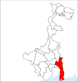
Uttar 24 Pargana
| North 24 Parganas (উওর ২৪ পরগনা) district | |
|---|---|
| District of West Bengal | |
| (উওর ২৪ পরগনা) district in West Bengal | |
| Country | India |
| State | West Bengal |
| Administrative division | Presidency |
| Headquarters | Barasat |
| Government | |
| • Lok Sabha constituencies | Bangaon, Barrackpore, Dum Dum, Barasat, Basirhat |
| • Assembly seats | Bagda, Bangaon Uttar, Bangaon Dakshin, Gaighata, Swarupnagar, Baduria, Habra, Ashoknagar, Amdanga, Bijpur, Naihati, Bhatpara, Jagatdal, Noapara, Barrackpore, Khardaha, Dum Dum Uttar, Panihati, Kamarhati, Baranagar, Dum Dum, Rajarhat New Town, Bidhannagar, Rajarhat Gopalpur, Madhyamgram, Barasat, Deganga, Haroa, Minakhan, Sandeshkhali, Basirhat Dakshin, Basirhat Uttar, Hingalganj |
| Area | |
| • Total | 4,094 km2 (1,581 sq mi) |
| Population (2011) | |
| • Total | 10,082,852 |
| • Density | 2,500/km2 (6,400/sq mi) |
| Demographics | |
| • Literacy | 84.95 percent |
| • Sex ratio | 949 |
| Major highways | NH 34, NH 35 |
| Average annual precipitation | 1579 mm |
| Website | Official website |
North 24 Parganas (Pron: pɔrɡɔnɔs) or abv. 24 PGS(N) is a district in southern West Bengal, of eastern India. North 24 Parganas extends in the tropical zone from latitude 22º11'6" north to 23º15'2" north and from longitude 88º20' east to 89º5' east. It is bordered to Nadia by north, to Bangladesh (Khulna Division) by north and east, to South 24 Parganas and Kolkata by south and to Kolkata, Howrah and Hoogly by west. Barasat is the district headquarters of North 24 Parganas.North 24 Parganas is West Bengal's most populous district and (following the splitting of the Thane district of Maharashtra in 2014) the most populated district in the whole of India. It is also the tenth-largest district in the State by area.
According to Ptolemy's Treatise on geography, written in the 2nd Century A.D., the ancient land of Gangaridi was stretched between the rivers Bhagirathi-Hoogly (lower Ganges) and Padma-Meghna. The modern-day 24 Parganas was the southern and the south-eastern territory of that legendary kingdom.
...
Wikipedia

