Barasat
|
Barasat বারাসত |
|
|---|---|
| Suburb/City | |
 |
|
| Location in West Bengal, India | |
| Coordinates: 22°43′N 88°29′E / 22.72°N 88.48°ECoordinates: 22°43′N 88°29′E / 22.72°N 88.48°E | |
| Country |
|
| State | West Bengal |
| District | North 24 Parganas |
| Government | |
| • Municipality Chairman | Sunil Mukherjee |
| • MP | Kakali Ghosh Dastidar |
| • MLA | Chiranjeet (Dipak) Chakrabarty |
| Elevation | 4 m (13 ft) |
| Population (2015) | |
| • Total | 199,648 |
| • Density | 2,223/km2 (5,760/sq mi) |
| Languages | |
| • Official | Bengali, English |
| Time zone | IST (UTC+5:30) |
| PIN | 700124 to 700126 |
| Telephone code | 91 33 2542 |
| Vehicle registration | WB26 |
| Lok Sabha constituency | Barasat |
| Vidhan Sabha constituency | Barasat |
| Website | north24parganas |
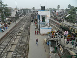
Barasat (/ˈbɑːrəˌsʌt/; Bengali: বারাসাত Barasat) is a suburb in the outskirts of Kolkata, West Bengal India and is the district headquarters of the district North 24 Parganas. It is a part of the area covered by Kolkata Metropolitan Development Authority. The town is an important railway and roadway junction. Barasat is also the name of a sub-division centring the city.
As an urban setup in the vicinity of the Kolkata, the town is within the area of Greater Kolkata. Several significant roads like National Highway 34 (Krishnanagar Road leading towards North Bengal), Jessore Road (road leading to Jessore in Bangladesh via Bongaon); road leading to Basirhat etc. cross through the town.
During the period of Moghuls, Ram Sundar Mitra had got the Laminar at Barasat town. Sankar Chakrabrorty, a commander of Pratapaditya, The king of Jessore (at present in Bangladesh), came to Barasat in 1600, and established himself in Barasat town. In 1700 AD Hazarat Ekdil Shah, the Muslim saint, started residing at Kazipara, Barasat. He was known as a social reformer. His tomb, located in Kazipara, is a pilgrimage place of Muslim community. Pratapaditya had made his way to Kolkata from Jessore and Sirajudoulla had made his way to Kolkata from Murshidabad via Barasat, which are later on converted into two National Highways.
...
Wikipedia

