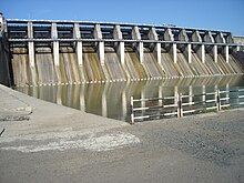
Upper Wardha Dam
| Upper Wardha Dam Nal Damayanti Sagar |
|
|---|---|
 |
|
|
Location of Upper Wardha Dam
Nal Damayanti Sagar in India Maharashtra |
|
| Official name | Upper Wardha Dam D02982 |
| Location | Morshi |
| Coordinates | 21°16′35″N 78°03′26″E / 21.27639°N 78.05722°ECoordinates: 21°16′35″N 78°03′26″E / 21.27639°N 78.05722°E |
| Opening date | 1993 |
| Owner(s) | Government of Maharashtra, India |
| Dam and spillways | |
| Type of dam |
Earthfill Gravity |
| Impounds | Wardha River |
| Height | 46.2 m (152 ft) (Spillway), 36.62 m (120.1 ft) Earth Dam |
| Length | 5,920 m (19,420 ft) (Spillway 268 m (879 ft) |
| Reservoir | |
| Total capacity | 786,480,000 cubic metres (live storage 614,790,000 cubic metres) |
| Catchment area | 4,302 km2 (1,661 sq mi) |
| Surface area | 9,748 ha (24,090 acres) |
|
Website Upper Wardha Dam |
|
The Upper Wardha Dam is an earthfill straight gravity dam across the Wardha River, a tributary of the Godavari River, near Simhora village in Morshi taluk in Amravati district in the Indian state of Maharashtra. The dam provides multipurpose benefits of irrigation, drinking water supply, flood control and hydropower generation.
The Upper Wardha Dam is also known as the Nala Damayanti Sagar, named after the famous characters Nala and Damayanti of an epic love story in Hindu mythology, Nala Damayanti.
The multipurpose Upper Wardha Dam project is considered the lifeline for Amravati city, and Morshi and Warud Talukas. It is an integral component of the Upper Wardha Irrigation Project, which envisages providing water for irrigation, drinking water supply and for industrial use and also flood control. Hydropower generation is planned only when irrigation develops.
The Wardha River, across which the Upper Wardha Dam is built, is a tributary of the Godavari River. From its origin, at an altitude of 785 m (2,575 ft) in Satpura Range from the Multai plateau in Betul District of Madhya Pradesh, the river flows 32 km (20 mi) in Madhya Pradesh and then enters into Maharashtra near the Multai plateau of the Satpuda range. It flows along the entire northern and western border of the Wardha district. After traversing 528 km (328 mi), it joins Wainganga River and together it is called the Pranhita, which ultimately flows into the Godavari River. Kar, Wena, Jam and Erai are its left-bank tributaries whereas Madu, Bembla and Penganga are the right-bank tributaries. The catchment area is hilly and forested in its upper reaches from its source and the lower reaches are flat wide valleys.
...
Wikipedia

