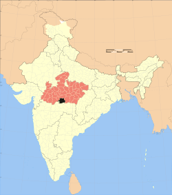
Betul District
|
Betul, Madhya Pradesh district बैतूल जिला |
|
|---|---|
| District of Madhya Pradesh | |
 Location of Betul, Madhya Pradesh district in Madhya Pradesh |
|
| Country | India |
| State | Madhya Pradesh |
| Administrative division | Narmadapuram |
| Headquarters | Betul, Madhya Pradesh |
| Government | |
| • Lok Sabha constituencies | Betul |
| Area | |
| • Total | 10,043 km2 (3,878 sq mi) |
| Population (2011) | |
| • Total | 1,575,247 (provisional) |
| Demographics | |
| • Literacy | 70.1% |
| • Sex ratio | 970 |
| Major highways | National Highway 69 |
| Website | Official website |
Betul District is a district of Madhya Pradesh state in central India. The city of Betul serves as its administrative headquarters. The district is a part of Narmadapuram Division.
According to the 2011 census Betul district has a population of 1,582,793, roughly equal to the nation of Gabon or the US state of Idaho. This gives it a ranking of 314th in India (out of a total of 640). The district has a population density of 466 inhabitants per square kilometre (1,210/sq mi). Its population growth rate over the decade 2001–2011 was 6.85%. Betul has a sex ratio of 962 females for every 1000 males, and a literacy rate of 85.4%.
The district has an area of 10043 km2. According to the provisional data of the 2011 census, population of the district is 1,575,247 (799,721 males and 775,526 females) with a sex ratio of 970 females per 1000 males. Population density is 157/km2. Total literacy rate is 70.1% (male 78.4% and female 61.6%).
The district is rich in tribal population. The tribal population of the district as per 2001 census is 5,49,907.first of all chhipa samaj find this place and then that is called BADNOOR. chhipa samaj The merchant of cloths firstly survive in betul . Main tribes inhabiting the district are Gonds and Korkus. The remaining population is Marathi including castes like Marathas, (katiya), Kunbis, Mali, Brahmins, Pal, Patil, pawars, Chamars, and sonis.
...
Wikipedia
