Uozu
|
Uozu 魚津市 |
||
|---|---|---|
| City | ||
|
||
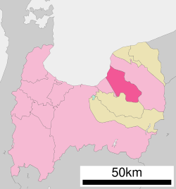
 Location of Uozu in Toyama Prefecture |
||
| Location in Japan | ||
| Coordinates: 36°49′N 137°25′E / 36.817°N 137.417°ECoordinates: 36°49′N 137°25′E / 36.817°N 137.417°E | ||
| Country | Japan | |
| Region | Chūbu (Hokuriku) | |
| Prefecture | Toyama Prefecture | |
| Government | ||
| • Mayor | Yoshinori Sawasaki (since May 2004) | |
| Area | ||
| • Total | 200.63 km2 (77.46 sq mi) | |
| Population (May 31, 2011) | ||
| • Total | 44,963 | |
| • Density | 224.11/km2 (580.4/sq mi) | |
| Symbols | ||
| • Tree | Pinus | |
| • Flower | Lilium speciosum, Azalea | |
| Time zone | Japan Standard Time (UTC+9) | |
| City hall address | 1-10-1 Shakadō, Uozu-shi, Toyama-ken 937-8555 |
|
| Website | www |
|
Uozu (魚津市 Uozu-shi?) is a city located in the eastern part of Toyama Prefecture, Japan between Namerikawa and Kurobe, stretching from Toyama Bay and the Japan Sea in the northwest to tall mountain ranges in the southeast. The highest mountains in Uozu are Sougadake and Kekachiyama, and the highest elevation in Uozu is 2,414 m. Several rapid rivers run through Uozu; from east to west, they are the Fuse River, the Katakai River, the Kado River, and the Hayatsuki River.
As of May 31, 2011, the city has an estimated population of 44,963, with 16,523 households and a population density of 224.11 persons per km². The total area is 200.63 km². Foreign nationals, mostly Chinese, Brazilians, and Thais, comprise 1% of the city's population.
The city was founded on April 1, 1952, and has sister city relationships with Chiang Mai City, Thailand (since 1989) and Ibara City, Japan (since 1982). The current mayor (as of October, 2006) is Mr. Yoshinori Sawasaki (澤崎義敬).
Uozu is located 3 hours by rail and 4.5 hours by car from Tokyo. Since March 2015, rail access is possible via Hokuriku Shinkansen high-speed train from nearby rail hub of Toyama. Uozu is served by two train lines, the Toyama Chihō Railway Main Line and the Ainokaze Toyama Railway line, running together from Uozu Station westward and separating eastward.
...
Wikipedia


