Untersberg
| Untersberg | |
|---|---|

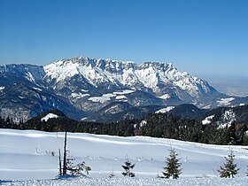
View from the south, in Göll massif. The Salzburg Hochthron is the peak on the right of the picture, the Berchtesgaden Hochthron the one on the left.
|
|
| Highest point | |
| Elevation | 1,973 m (6,473 ft) |
| Coordinates | 47°42′N 12°59′E / 47.700°N 12.983°E |
| Geography | |
| Location |
Germany Austria |
| Parent range | Berchtesgaden Alps |
| Climbing | |
| First ascent | 12th century |
The Untersberg is a massif of the Berchtesgaden Alps, a prominent northern spur that straddles the border between Berchtesgaden, Germany and Salzburg, Austria. The highest peak of the table-top mountain is the Berchtesgaden Hochthron at 1,973 metres (6,473 ft). The "distinctive, lopsided peak" gained international fame as the mountain featured at the beginning and end of the movie The Sound of Music in 1965.
The Untersberg rises at the rim of the Northern Limestone Alps, immediately at the Salzburg Basin and the broad Salzach Valley. Neighbouring peaks are the Hoher Göll in the southeast and Mt. Watzmann in the south, beyond the Berchtesgaden Basin. In the northwest, the Saalach Valley with Bad Reichenhall separates it from the Hochstaufen mountain range. About two-thirds of the area, including the Berchtesgaden Hochthron, is located in Germany, while the northernmost steep edge above Salzburg belongs to Austria.
The mountain is popular with tourists due to its proximity to the city of Salzburg: less than 16 kilometres (9.9 mi) south of the city centre and within easy reach by bus, for example city bus line 25 to Grödig, which runs every 15 minutes on weekdays. Several trails lead to the top, though most people prefer the Untersbergbahn cable car. Constructed over a period of over two years, and opening in April 1961, the eight and a half minute journey lifts passengers from the lower terminus at the village of St. Leonhard at 456 m (1,496 ft) over 1,320 m (4,330 ft) to the Geiereck spur at an altitude of 1,776 m (5,827 ft), transporting them a horizontal distance of almost 2.5 km (1.6 mi).
...
Wikipedia
