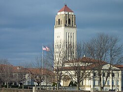
Unity Village, Missouri
| Unity Village, Missouri | |
|---|---|
| Village | |

Unity Church headquarters
|
|
 Location of Unity Village, Missouri |
|
 U.S. Census Map |
|
| Coordinates: 38°56′47″N 94°23′58″W / 38.94639°N 94.39944°WCoordinates: 38°56′47″N 94°23′58″W / 38.94639°N 94.39944°W | |
| Country | United States |
| State | Missouri |
| County | Jackson |
| Area | |
| • Total | 1.97 sq mi (5.10 km2) |
| • Land | 1.90 sq mi (4.92 km2) |
| • Water | 0.07 sq mi (0.18 km2) |
| Elevation | 935 ft (285 m) |
| Population (2010) | |
| • Total | 99 |
| • Estimate (2016) | 80 |
| • Density | 50/sq mi (19/km2) |
| Time zone | Central (CST) (UTC-6) |
| • Summer (DST) | CDT (UTC-5) |
| ZIP codes | 64065 |
| Area code(s) | 816 |
| FIPS code | 29-75202 |
| GNIS feature ID | 0728064 |
Unity Village is a village in Jackson County, Missouri, United States. The population was 99 at the 2010 census. The village is the world headquarters of Unity, which has over 2 million followers.
Unity Village is located 15 miles (24.1 km) southeast of downtown Kansas City, Missouri
Unity Village is located at 38°56′47″N 94°23′58″W / 38.94639°N 94.39944°W (38.946283, -94.399311).
According to the United States Census Bureau, the village has a total area of 1.97 square miles (5.10 km2), of which, 1.90 square miles (4.92 km2) of it is land and 0.07 square miles (0.18 km2) is water.
On July 1, 2015 a tornado ripped roofs to shreds. However, it only lasted a few seconds.
As of the census of 2010, there were 99 people, 65 households, and 11 families residing in the village. The population density was 52.1 inhabitants per square mile (20.1/km2). There were 73 housing units at an average density of 38.4 per square mile (14.8/km2). The racial makeup of the village was 85.9% White, 7.1% African American, 2.0% Asian, and 5.1% from two or more races. Hispanic or Latino of any race were 6.1% of the population.
...
Wikipedia
