Union Bridge, Maryland
| Union Bridge, Maryland | |
|---|---|
| Town | |

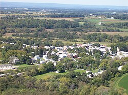
A view of Union Bridge
|
|
 |
|
| Coordinates: 39°34′7″N 77°10′39″W / 39.56861°N 77.17750°WCoordinates: 39°34′7″N 77°10′39″W / 39.56861°N 77.17750°W | |
| Country | United States |
| State | Maryland |
| County | Carroll |
| Area | |
| • Total | 1.05 sq mi (2.72 km2) |
| • Land | 1.04 sq mi (2.69 km2) |
| • Water | 0.01 sq mi (0.03 km2) |
| Elevation | 456 ft (139 m) |
| Population (2010) | |
| • Total | 975 |
| • Estimate (2012) | 973 |
| • Density | 937.5/sq mi (362.0/km2) |
| Time zone | Eastern (EST) (UTC-5) |
| • Summer (DST) | EDT (UTC-4) |
| ZIP code | 21791 |
| Area code(s) | 410,443,667 |
| FIPS code | 24-79350 |
| GNIS feature ID | 0591452 |
| Website | www |
Union Bridge is a town in Carroll County, Maryland, United States. The population was 975 at the 2010 census.
Much of the town was added to the National Register of Historic Places as the Union Bridge Historic District in 1994.
Union Bridge is located at 39°34′7″N 77°10′39″W / 39.56861°N 77.17750°W (39.568550, -77.177618).
According to the United States Census Bureau, the town has a total area of 1.05 square miles (2.72 km2), of which, 1.04 square miles (2.69 km2) is land and 0.01 square miles (0.03 km2) is water.
As of the census of 2010, there were 975 people, 394 households, and 251 families residing in the town. The population density was 937.5 inhabitants per square mile (362.0/km2). There were 429 housing units at an average density of 412.5 per square mile (159.3/km2). The racial makeup of the town was 91.7% White, 5.1% African American, 0.3% Native American, 0.7% from other races, and 2.2% from two or more races. Hispanic or Latino of any race were 1.4% of the population.
...
Wikipedia
