Undavalli
| Undavalli | |
|---|---|
| Neighbourhood | |

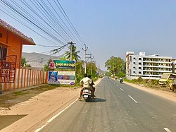
Undavalle village along Amaravathi road
|
|
| Location in Andhra Pradesh, India | |
| Coordinates: 16°29′45″N 80°34′48″E / 16.4957°N 80.5800°ECoordinates: 16°29′45″N 80°34′48″E / 16.4957°N 80.5800°E | |
| Country | India |
| State | Andhra Pradesh |
| District | Guntur |
| Mandal | Tadepalle |
| Area | |
| • Total | 13.05 km2 (5.04 sq mi) |
| Elevation | 24 m (79 ft) |
| Population (2011) | |
| • Total | 9,743 |
| • Density | 750/km2 (1,900/sq mi) |
| Languages | |
| • Official | Telugu |
| Time zone | IST (UTC+5:30) |
| PIN | 522501 |
| Vehicle registration | AP–07 |
Undavalli is an neighbourhood of Amaravati, the state capital of the Indian state of Andhra Pradesh. It was a village in Tadepalle mandal of in Guntur district, prior to its denotification as gram panchayat. 5th century Buddhist and Hindu Undavalli Caves which signify Monolithic Indian rock-cut architecture are present at this place.
Undavalli is located at 16°29′45″N 80°34′48″E / 16.4957°N 80.5800°E. It has an average elevation of 24 m (79 ft). It is situated on the south bank of Krishna River.
Undavalli gram panchayat is the local self-government of the village. The elected members of the gram panchayat is headed by a sarpanch. The sarpanch of the villages was awarded Nirmala Grama Puraskaram for the year 2013.
The Vijayawada-Amaravati road connects Undavalli with Vijayawada.APSRTC operates buses on this route from Pandit Nehru bus station of Vijayawada.
...
Wikipedia

