Ulagansky District
| Ulagansky District Улаганский район (Russian) Улаган аймак (Altay) |
|
|---|---|
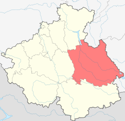
 Location of Ulagansky District in the Altai Republic |
|
| Coordinates: 51°57′N 85°57′E / 51.950°N 85.950°ECoordinates: 51°57′N 85°57′E / 51.950°N 85.950°E | |
 Chulymshan River area, a protected area of Russia in Ulagansky District |
|
| Location | |
| Country | Russia |
| Federal subject | Altai Republic |
| Administrative structure (as of October 2015) | |
| Administrative center | selo of Ulagan |
| Administrative divisions: | |
| Rural settlements | 7 |
| Inhabited localities: | |
| Rural localities | 13 |
| Municipal structure (as of March 2015) | |
| Municipally incorporated as | Ulagansky Municipal District |
| Municipal divisions: | |
| Urban settlements | 0 |
| Rural settlements | 7 |
| Statistics | |
| Area | 18,367 km2 (7,092 sq mi) |
| Population (2010 Census) | 11,388 inhabitants |
| • Urban | 0% |
| • Rural | 100% |
| Density | 0.62/km2 (1.6/sq mi) |
| Time zone | KRAT (UTC+07:00) |
| Established | October 19, 1923 |
| Official website | |
| on | |
| 2010 Census | 11,388 |
|---|---|
| 2002 Census | 11,581 |
| 1989 Census | 11,176 |
| 1979 Census | 9,323 |
Ulagansky District (Russian: Улага́нский райо́н; Altai: Улаган аймак) is an administrative and municipal district (raion), one of the ten in the Altai Republic, Russia. It is located in the east of the republic. The area of the district is 18,367 square kilometers (7,092 sq mi). Its administrative center is the rural locality (a selo) of Ulagan. As of the 2010 Census, the total population of the district was 11,388, with the population of Ulagan accounting for 28.3% of that number.
The district is located in a mountainous area, away from major roads. A large part of the district along the mountainous eastern border is in the Altai Nature Reserve.
The district was established on October 19, 1923 within Oirot Autonomous Oblast.
Within the framework of administrative divisions, Ulagansky District is one of the ten in the Altai Republic. As a municipal division, the district is incorporated as Ulagansky Municipal District. Both administrative and municipal districts are divided into the same seven rural settlements, comprising thirteen rural localities. The selo of Ulagan serves as the administrative center of both the administrative and municipal district.
...
Wikipedia
