US Route 130
| U.S. Route 130 | ||||
|---|---|---|---|---|

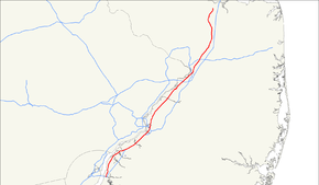
US 130 highlighted in red
|
||||
| Route information | ||||
| Auxiliary route of US 30 | ||||
| Maintained by NJDOT | ||||
| Length: | 83.46 mi (134.32 km) | |||
| Existed: | 1927 – present | |||
| Major junctions | ||||
| South end: |
|
|||
|
||||
| North end: |
|
|||
| Location | ||||
| Counties: | Salem, Gloucester, Camden, Burlington, Mercer, Middlesex | |||
| Highway system | ||||
|
||||
New Jersey State Highway Routes
U.S. Route 130 (US 130) is a north–south U.S. Highway completely within the state of New Jersey. It runs 83.46 mi (134.32 km) from Interstate 295 (I-295) and US 40 at Deepwater in Pennsville Township, Salem County, where the road continues south as Route 49, north to US 1 in North Brunswick Township, Middlesex County, where Route 171 continues north into New Brunswick. The route briefly runs concurrent with its parent US 30 near Camden, about one-third of the way to New Brunswick. The road runs within a close distance of I-295 south of Bordentown and a few miles from the New Jersey Turnpike for its entire length, serving as a major four- to six-lane divided local road for most of its length. US 130 passes through many towns including Penns Grove, Bridgeport, Westville, Camden, Pennsauken, Burlington, Bordentown, Hightstown, and North Brunswick.
...
Wikipedia

