US 44
| U.S. Route 44 | |
|---|---|
 |
|
| Route information | |
| Maintained by NYSDOT, NYSBA, ConnDOT, RIDOT, and MassDOT | |
| Length: | 236.7 mi (380.9 km) |
| Existed: | 1935 – present |
| Major junctions | |
| West end: |
|
|
|
|
| East end: |
|
| Location | |
| States: | New York, Connecticut, Rhode Island, Massachusetts |
| Highway system | |
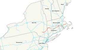
U.S. Route 44 is an east–west United States highway that runs for 237 miles (381 km) through four states in the Northeastern region of the United States. The western terminus is at U.S. Route 209 and New York State Route 55 in Kerhonkson, a hamlet in the Hudson Valley region of New York. The eastern terminus is at Massachusetts Route 3A in Plymouth, Massachusetts.
US 44 begins at US 209/NY 55 in the hamlet of Kerhonkson in Ulster County. Route 44 is about 66 miles (106 km) long in the state, progressing through Ulster and Dutchess Counties. The route crosses into Connecticut after intersecting with New York State Route 22 in Millerton.
From the New York state line at Salisbury to the Rhode Island state line at Putnam, US 44 runs for a total of 106.03 miles (170.64 km) in Connecticut. Most of US 44 is known in the state as the Jonathan Trumbull Highway. It begins as rural arterial road in Litchfield county, going through the towns of North Canaan, Norfolk, Colebrook, Winchester, Barkhamsted, and New Hartford. It is a 2-lane road with 4-lane sections in Winchester.
...
Wikipedia

