U. S. Route 219
| U.S. Route 219 | |||||||||||||
|---|---|---|---|---|---|---|---|---|---|---|---|---|---|
 |
|||||||||||||
| Route information | |||||||||||||
| Auxiliary route of US 19 | |||||||||||||
| Length: | 535 mi (861 km) | ||||||||||||
| Existed: | 1926 – present | ||||||||||||
| Major junctions | |||||||||||||
| South end: |
|
||||||||||||
|
|||||||||||||
| North end: |
|
||||||||||||
| Location | |||||||||||||
| States: | Virginia, West Virginia, Maryland, Pennsylvania, New York | ||||||||||||
| Highway system | |||||||||||||
|
|||||||||||||
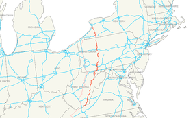
U.S. Route 219 is a spur of U.S. Route 19. It runs for 535 miles (861 km) from West Seneca, New York at an interchange with Interstate 90, to Rich Creek, Virginia, intersecting at U.S. Route 460. U.S. 219 is found (from north to south) in New York, Pennsylvania, Maryland, West Virginia, and Virginia. Much of the Route in West Virginia follows the old Indian warpath known as the Seneca Trail (Great Indian Warpath).
U.S. Route 219 starts in Rich Creek at U.S. Route 460, and heads northeast to the West Virginia state line. Until the early 1980s, US 219 continued southwest with US 460 from Rich Creek, re-entering West Virginia to end at US 19 in Bluefield. It now only runs 1.3 miles (2.1 km) in Virginia.
US 219 was initially added to the state highway system in the early 1920s as State Route 231. It became State Route 216 in the 1928 renumbering and State Route 124 in the 1933 renumbering, finally becoming part of the extended US 219 (along with State Route 8, now U.S. Route 460, west of Rich Creek) in the late 1930s.
...
Wikipedia

