U.S. Route 58 Alternate (Virginia)
| U.S. Route 58 Alternate | ||||
|---|---|---|---|---|
 |
||||
| Route information | ||||
| Maintained by VDOT | ||||
| Length: | 87.40 mi (140.66 km) | |||
| Existed: | c. 1950 – present | |||
| Major junctions | ||||
| West end: |
|
|||
|
||||
| East end: |
|
|||
| Location | ||||
| Counties: | Lee, Wise, City of Norton, Russell, Washington, | |||
| Highway system | ||||
|
||||
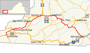
U.S. Route 58 Alternate (US 58 Alt.) is a 87.40-mile-long (140.66 km) alternate route to US 58 in western Virginia. The route is a northern bypass to US 58 which stays closer to the Tennessee border and serves Gate City and Bristol.
US 58 Alt. begins at the intersection of Main Street and Park Street in the center of the town of Jonesville, the county seat of Lee County. US 58 heads west along Main Street and south along Park Street, then east along Wilderness Road. US 58 Alt. heads east along two-lane Main Street, then north along the Trail of the Lonesome Pine to exit the town. The highway expands to a four-lane divided highway north of the town limits, then curves east. US 58 Alt. temporarily becomes undivided through Ben Hur, where the highway begins to parallel CSX's Cumberland Valley Subdivision rail line. The highway drops to two lanes and crosses over the rail line as it enters the town of Pennington Gap. US 58 Alt. follows Morgan Avenue through the town, where it briefly runs concurrently with US 421 between Doris Avenue and Woodway Road.
US 58 Alt. expands to a four-lane divided highway again as it exits Pennington Gap. The highway crosses over the railroad again at the west end of Dryden and leaves the railroad as the U.S. Highway crosses the Powell River. US 58 Alt. returns to the vicinity of the river and railroad and enters Wise County, where its name becomes Pennington Gap Highway, just west of Big Stone Gap. The highway reduces to two lanes and enters the town as Cumberland Avenue, then veers onto Wood Avenue, which passes the Southwest Virginia Museum. In the center of town, US 58 Alt. turns south onto Fifth Street, which carries U.S. Route 23 Business (US 23 Bus.). The U.S. Highway special routes turn east onto Gilley Avenue to leave the town. The road expands to a four-lane divided highway shortly before a four-ramp partial cloverleaf interchange with US 23 (Orby Cantrell Highway) north of the campus of Mountain Empire Community College. US 23 Bus. ends at the interchange while US 58 Alt. joins the US 23 divided highway.
...
Wikipedia

