U.S. Route 35 (West Virginia)
| U.S. Route 35 | ||||||||||
|---|---|---|---|---|---|---|---|---|---|---|
 |
||||||||||
| Route information | ||||||||||
| Length: | 417.73 mi (672.27 km) | |||||||||
| Major junctions | ||||||||||
| South end: |
|
|||||||||
|
||||||||||
| North end: |
|
|||||||||
| Location | ||||||||||
| States: | West Virginia, Ohio, Indiana | |||||||||
| Highway system | ||||||||||
|
||||||||||
|
U.S. Route 35 Spur |
|
|---|---|
| Location: | Teays Valley, West Virginia |
| Length: | 0.20 mi (0.32 km) |
|
U.S. Route 35 Business |
|
|---|---|
| Location: | Xenia, Ohio |
| Length: | 5.7 mi (9.2 km) |
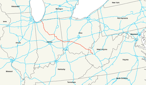
U.S. Route 35 (US 35) is a United States highway that runs northwest-southeast for approximately 412 miles (663 km) from northern Indiana to the western suburbs of Charleston, West Virginia. Although the highway is physically southeast-northwest, it is nominally north-south. The highway's northern terminus is in Michigan City, Indiana, at U.S. Route 20. Its southern terminus is in Scott Depot, West Virginia, at Interstate 64. Currently, the West Virginia portion of the highway is being expanded to four lanes, mostly along a completely new route. The Ohio portion has already been upgraded to a four-lane highway/freeway between the West Virginia state line and Trotwood, west of Dayton.
US 35 is signed south–north in West Virginia and Indiana, while in Ohio, it is signed west–east.
In West Virginia from Scott Depot to Point Pleasant, US 35 is currently being expanded to a four-lane expressway. Currently the route is four lanes from I-64 to the junction with the bridge to Buffalo (West Virginia Route 869), which serves the large Toyota engine and transmission plant in Buffalo, and continues as a 2-lane route for 14.6 miles (23.5 km) to another four lane section of eight miles (6 km) to the Ohio River, which is the state line.
...
Wikipedia

