U.S. Highway 412 (Oklahoma)
| U.S. Route 412 | ||||
|---|---|---|---|---|

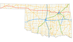
US-412 highlighted in red on a road map of Oklahoma
|
||||
| Route information | ||||
| Maintained by ODOT and OTA | ||||
| Length: | 504.11 mi (811.29 km) | |||
| Existed: | February 1, 1988 – present | |||
| Major junctions | ||||
| West end: |
|
|||
|
|
||||
| East end: |
|
|||
| Highway system | ||||
|
Oklahoma State Highway System
|
||||
| State Highway 412A | |
|---|---|
| Location: | Oaks, Oklahoma |
| Length: | 2.98 mi (4.80 km) |
| Existed: | ca. 1957–present |
| State Highway 412B | |
|---|---|
| Location: | Mayes County, Oklahoma |
| Length: | 5.33 mi (8.58 km) |
| Existed: | ca. 1986–present |
| State Highway 412P | |
|---|---|
| Location: | Rogers County, Oklahoma |
| Length: | 1.26 mi (2.03 km) |
U.S. Route 412 (abbreviated US-412) is a U.S. highway in the south-central portion of the United States, connecting Springer, New Mexico to Columbia, Tennessee. A 504.11-mile (811.29 km) section of the highway crosses the state of Oklahoma, traversing the state from west to east. Entering the state southwest of Boise City, US-412 runs the length of the Oklahoma Panhandle and serves the northern portion of the state's main body, before leaving the state at West Siloam Springs. Along the way, the route serves many notable cities and towns, including Boise City, Guymon, Woodward, Enid, and the state's second-largest city, Tulsa.
US-412 has two tolled sections, both of them in Oklahoma—the Cimarron Turnpike and the Cherokee Turnpike. The tolled portions of the highway are operated by the Oklahoma Turnpike Authority (OTA), with the remainder of the route maintained by the Oklahoma Department of Transportation (ODOT). In addition to the freeway-grade turnpikes, a large amount of the highway has been upgraded to four-lane expressway facilities, although some portions remain two-lane, especially in the Panhandle. Much of US-412's route through Oklahoma either overlaps or is in close proximity to that of US-64.
...
Wikipedia

