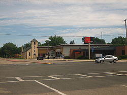
Springer, New Mexico
| Springer, New Mexico | |
|---|---|
| Town | |

Downtown Springer (2008)
|
|
 Location within Colfax County and New Mexico |
|
| Coordinates: 36°21′50″N 104°35′37″W / 36.36389°N 104.59361°WCoordinates: 36°21′50″N 104°35′37″W / 36.36389°N 104.59361°W | |
| Country | United States |
| State | New Mexico |
| County | Colfax |
| Area | |
| • Total | 1.5 sq mi (3.8 km2) |
| • Land | 1.5 sq mi (3.8 km2) |
| • Water | 0.0 sq mi (0.0 km2) |
| Elevation | 5,797 ft (1,767 m) |
| Population (2010) | |
| • Total | 1,047 |
| • Density | 710/sq mi (280/km2) |
| Time zone | Mountain (MST) (UTC-7) |
| • Summer (DST) | MDT (UTC-6) |
| ZIP codes | 87729, 87747 |
| Area code(s) | 575 |
| FIPS code | 35-74800 |
| GNIS feature ID | 0895273 |
Springer is a town in Colfax County, New Mexico, United States. Its population was 1,047 at the 2010 census.
Springer was the county seat of Colfax County from 1882—1897. Springer was part of the Lucien B. Maxwell land grant. It is near the Cimarron Cutoff of the Santa Fe Trail. There was a range war in Springer in 1881, when Maxwell sold his land grant to a group of investors.
The former Colfax County Courthouse in Springer is now a visitor center and museum. It was built for $9,800 in the early 1880s. It has had multiple uses over the years, including the site of the Raton Reform School for Boys (1910–1917). It has also been a library, the Springer town hall, and a jail. Outside the courthouse museum is a tall monument to the Ten Commandments. There is also a marker honoring Lance Corporal Chad Robert Hildebrandt (October 12, 1983—October 17, 2005), the first casualty in the Iraq War from Springer.
The Springer Correctional Center, operated by the New Mexico Corrections Department, is located 2 miles (3 km) northwest of Springer. The correctional center is one of New Mexico's oldest detention facilities, having begun operation in 1909 as the New Mexico Boys' School.
Springer is located in southern Colfax County at 36°21′50″N 104°35′37″W / 36.36389°N 104.59361°W (36.363976, -104.593491). It is in the valley of the Cimarron River, 6 miles (10 km) west of where that river flows into the Canadian River.
...
Wikipedia
