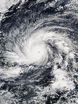
Typhoon Hagupit (2014)
| Typhoon (JMA scale) | |
|---|---|
| Category 5 (Saffir–Simpson scale) | |

Typhoon Hagupit shortly before peak intensity on December 4
|
|
| Formed | November 30, 2014 |
| Dissipated | December 12, 2014 |
| Highest winds |
10-minute sustained: 215 km/h (130 mph) 1-minute sustained: 285 km/h (180 mph) |
| Lowest pressure | 905 hPa (mbar); 26.72 inHg |
| Fatalities | 18 confirmed |
| Damage | $114 million (2014 USD) |
| Areas affected | Caroline Islands, Palau, Philippines, Vietnam |
| Part of the 2014 Pacific typhoon season | |
Typhoon Hagupit, known in the Philippines as Typhoon Ruby, was the second most intense tropical cyclone in 2014. Hagupit particularly impacted the Philippines in early December while gradually weakening, killing 18 people and causing $114 million (2014 USD) in the country. Prior to making landfall, Typhoon Hagupit was considered the worst threat to the Philippines in 2014; fortunately, the disaster was significantly smaller than 2013's Typhoon Haiyan.
Hagupit developed into the 22nd tropical storm of the annual typhoon season on December 1, 2014 and became that year’s eleventh typhoon the next day. Under a favorable environment, the typhoon underwent rapid deepening and reached peak intensity northwest of Palau on December 4, with a clear eye. Hagupit slightly weakened but restrengthened on December 5, but subsequently started to weaken again, due to subsidence associated with an upper-level trough.
The typhoon made first landfall over the province of Eastern Samar in the Philippines on December 6, and then made three other landfalls over the country. For land interaction and the slow movement, Hagupit weakened into a tropical storm on December 8. When arriving at the South China Sea on December 9, deep convection of the storm diminished significantly. The system could not overcome the hostile environment and weakened into a tropical depression on December 11, before it eventually dissipated southeast of Ho Chi Minh City on December 12.
A tropical disturbance formed about 130 km (80 mi) north of the equator and about 530 km (330 mi) south-southwest of Kosrae in the afternoon of November 29, as well as the Joint Typhoon Warning Center (JTWC) issued a Tropical Cyclone Formation Alert on the next day for consolidating under favorable upper-level conditions. Early on December 1, the Japan Meteorological Agency (JMA) upgraded it to a tropical depression, so did the JTWC with the 22W designation. Only six hours later, the JMA upgraded the system to a tropical storm and named it Hagupit, and the JTWC also upgraded it to a tropical storm, owing to a consolidating low-level circulation center (LLCC) with the tightly curved banding wrapping into. However, the RSMC best track data indicated that the system had been already a tropical depression since November 30 and a tropical storm early on December 1. With low vertical wind shear and excellent radial outflow, Hagupit consolidated further on December 2, so it was upgraded to a severe tropical storm by the JMA and a typhoon by the JTWC at noon. Late on the same day, the JMA upgraded it to a typhoon when it began to track west-northwestward along the southern periphery of the subtropical ridge.
...
Wikipedia
