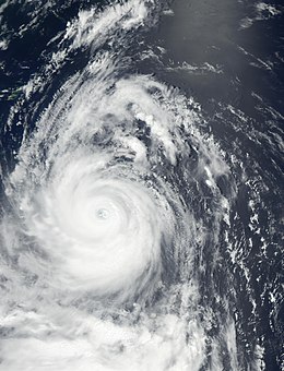
Typhoon Chataan
| Typhoon (JMA scale) | |
|---|---|
| Category 4 (Saffir–Simpson scale) | |

Typhoon Chataan at peak intensity on July 8, 2002
|
|
| Formed | June 27, 2002 |
| Dissipated | July 13, 2002 |
| (Extratropical after July 11, 2002) | |
| Highest winds |
10-minute sustained: 175 km/h (110 mph) 1-minute sustained: 240 km/h (150 mph) |
| Lowest pressure | 930 hPa (mbar); 27.46 inHg |
| Fatalities | 54 direct, 1 missing |
| Damage | $660 million (2002 USD) |
| Areas affected | Chuuk, Guam, Japan |
| Part of the 2002 Pacific typhoon season | |
Typhoon Chataan was the deadliest natural disaster in the history of Chuuk, a state in the Federated States of Micronesia (FSM). The typhoon formed on June 28, 2002, near the FSM, and for several days it meandered while producing heavy rainfall across the region. On Chuuk, the highest 24-hour precipitation total was 506 mm (19.9 in), which was greater than the average monthly total. The rain produced floods up to 1.5 m (4.9 ft) deep, causing landslides across the island that killed 47 people. There was also one death on nearby Pohnpei, and damage in the FSM totaled over $100 million.
After affecting the FSM, Chataan began a northwest track as an intensifying typhoon. Its eye passed just north of Guam on July 4, though the eyewall moved across the island and dropped heavy rainfall. Totals were highest in southern Guam, peaking at 536 mm (21.1 in). Flooding and landslides from the storm severely damaged or destroyed 1,994 houses. Damage on the island totaled $60.5 million, and there were 23 injuries. The typhoon also affected Rota in the Northern Marianas Islands with gusty winds and light rainfall. Typhoon Chataan attained its peak intensity of 175 km/h (110 mph) on July 8. It weakened while turning to the north, and after diminishing to a tropical storm Chataan struck eastern Japan on July 10. High rainfall, peaking at 509 mm (20.0 in), flooded 10,270 houses. Damage in Japan totaled about $500 million.
The name Chataan means "rainy day" in the Chamorro language, which is spoken on Guam. The Philippine Atmospheric, Geophysical and Astronomical Services Administration (PAGASA) named the storm Gloria while the typhoon was in the vicinity of the country.
On June 27, 2002, the monsoon trough spawned a tropical disturbance southwest of Pohnpei. The system rapidly organized that day, and at 2000 UTC the Joint Typhoon Warning Center (JTWC) issued a tropical cyclone formation alert. Early on June 28, the Japan Meteorological Agency (JMA) classified the system as a tropical depression near the Mortlock Islands in the Federated States of Micronesia; around the same time, the JTWC also initiated storm advisories. Early on June 29, the JTWC upgraded the system to Tropical Storm 08W, and shortly thereafter the JMA named the system Tropical Storm Chataan. After moving northwestward, the storm turned to the east, resuming a northwest track on June 30 due to a subtropical ridge to the north. The track was erratic because the storm had not yet separated from the monsoon trough. By June 30, Chataan had steadily strengthened to severe tropical storm status, with 10-minute maximum sustained winds of 95 km/h (60 mph).
...
Wikipedia
