Tyler, Texas metropolitan statistical area
| Smith County, Texas | ||
|---|---|---|

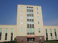
Smith County Courthouse in Tyler
|
||
|
||
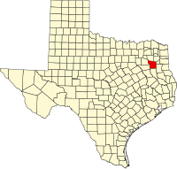
 Location in the U.S. state of Texas |
||
 Texas's location in the U.S. |
||
| Founded | July 1846 | |
| Seat | Tyler | |
| Largest city | Tyler | |
| Area | ||
| • Total | 950 sq mi (2,460 km2) | |
| • Land | 921 sq mi (2,385 km2) | |
| • Water | 28 sq mi (73 km2), 3.0% | |
| Population | ||
| • (2010) | 209,714 | |
| • Density | 228/sq mi (88/km²) | |
| Congressional district | 1st | |
| Time zone | Central: UTC-6/-5 | |
| Website | www |
|
Smith County is in the U.S. state of Texas. As of the 2010 census, its population was 209,714. Its county seat is Tyler. Smith County is named for James Smith, a general during the Texas Revolution.
Smith County is part of the Tyler, TX Metropolitan Statistical Area as well as the Tyler-Jacksonville, TX Tyler-Jacksonville Combined Statistical Area.
The first known inhabitants of the area now known as Smith County were the Caddo Indians. In July 1846 Smith County separated from the Nacogdoches District and was named for James Smith, a General of the Texas Revolution. It was at this time that Tyler was designated as the county seat.
Camp Ford was the largest Confederate Prisoner of War Camp west of the Mississippi River during the American Civil War and was where Sheriff Jim Reed of Collin County and Judge McReynolds, former chief justice of the district, were seized and lynched by "Regulators." The original site of the Camp stockade is now a public historic park, owned by Smith County, Texas, and managed by the Smith County Historical Society. The park contains a kiosk, paved trail, interpretive signage, a cabin reconstruction, and a picnic area. It is located on Highway 271, 0.8 miles north of Loop 323.
The Smith County Historical Society, a 501(c)(3) non-profit organization, was founded in 1959 by individuals and business firms dedicated to discovering, collecting and preserving data, records and other items relating to the history of Smith County, Texas. More information can be found at the Smith County Historical Society Website.
According to the U.S. Census Bureau, the county has a total area of 950 square miles (2,500 km2), of which 921 square miles (2,390 km2) is land and 28 square miles (73 km2) (3.0%) is water.
The county infrastructure includes some 1,180 miles (1,900 km) of two lane county road.
...
Wikipedia

