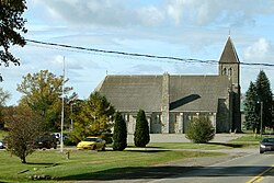
Tyendinaga, Ontario
| Tyendinaga | |
|---|---|
| Township (lower-tier) | |
| Township of Tyendinaga | |

Marysville
|
|
| Coordinates: 44°18′N 77°12′W / 44.300°N 77.200°WCoordinates: 44°18′N 77°12′W / 44.300°N 77.200°W | |
| Country |
|
| Province |
|
| County | Hastings |
| Incorporated | 1820 |
| Government | |
| • Type | Township |
| • Reeve | Rick Phillips |
| • Federal riding | Prince Edward—Hastings |
| • Prov. riding | Prince Edward—Hastings |
| Area | |
| • Land | 313.00 km2 (120.85 sq mi) |
| Population (2011) | |
| • Total | 4,150 |
| • Density | 13.3/km2 (34/sq mi) |
| Time zone | EST (UTC-5) |
| • Summer (DST) | EDT (UTC-4) |
| Postal Code | K0K |
| Area code(s) | 613 |
| Website | www.tyendinagatownship .com |
Tyendinaga is a township in the Canadian province of Ontario, located in Hastings County. The community takes its name from a variant spelling of Mohawk leader Joseph Brant's traditional Mohawk name, Thayendanegea.
The township comprises the communities of Albert, Blessington, Chisholms Mills, Ebenezer, Halston, Kingsford, Lonsdale, Lonsdale Station, Melrose, Marysville, Milltown, Myrehall, Naphan, Read and Shannonville.
Population trend:
Mother tongue:
...
Wikipedia

