Tuxedo Park, New York
| Tuxedo Park, New York | |
|---|---|
| Village | |
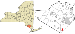
 Location in Orange County and the state of New York. |
|
| Location within the state of New York | |
| Coordinates: 41°12′5″N 74°12′6″W / 41.20139°N 74.20167°WCoordinates: 41°12′5″N 74°12′6″W / 41.20139°N 74.20167°W | |
| Country | United States |
| State | New York |
| County | Orange |
| Government | |
| • Mayor | Mary Jo Guinchard |
| Area | |
| • Total | 3.2 sq mi (8.4 km2) |
| • Land | 2.7 sq mi (6.9 km2) |
| • Water | 0.6 sq mi (1.4 km2) |
| Elevation | 407 ft (124 m) |
| Population (2010) | |
| • Total | 623 |
| Time zone | Eastern (EST) (UTC-5) |
| • Summer (DST) | EDT (UTC-4) |
| ZIP code | 10987 |
| Area code(s) | 845 Exchange: 351 |
| FIPS code | 36-75803 |
| GNIS feature ID | 0968011 |
| Location | Tuxedo Park, New York |
| Built | 1886 |
| Architect |
Bruce Price McKim, Mead & White Russell Sturgis |
| Architectural style | Tudor Revival, Italianate, Queen Anne |
| NRHP Reference # | 80002740 |
| Added to NRHP | March 13, 1980 |
Tuxedo Park is a village in Orange County, New York, United States. The population was 623 at the 2010 census. It is part of the Poughkeepsie–Newburgh–Middletown, NY, Metropolitan Statistical Area as well as the larger New York–Newark–Bridgeport, NY-NJ-CT-PA Combined Statistical Area. The name is derived from a Native American word of the Lenape language, tucsedo or p'tuxseepu, which is said to mean "crooked water" or "crooked river."
Tuxedo Park is a village within the southern part of the town of Tuxedo, near New York Route 17 and the New York State Thruway.
The park is located in the Ramapo Mountains. In the colonial era, it acquired a reputation for undeveloped iron deposits. In consequence, a company formed in England and headed by William Alexander, Lord Stirling, acquired a large tract in the neighborhood. The company built furnaces near Ringwood and opened mines on the Ramapo River near Sterling Lake. Pierre Lorillard II acquired the company and its land holdings in 1790. Once the iron deposits were depleted, the land was used for lumbering.
...
Wikipedia


