Tutuila Island

Tutuila and Aunu'u from space.
|
|
 |
|
| Geography | |
|---|---|
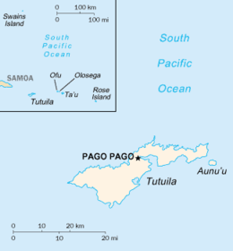
| Location | Map of Tutuila Island in American Samoa in Pacific Ocean |
| Coordinates | 14°17′42″S 170°42′00″W / 14.295°S 170.70°W |
| Archipelago | Samoan Islands |
| Area | 142.3 km2 (54.9 sq mi) |
| Highest elevation | 653 m (2,142 ft) |
| Highest point | Matafao Peak |
| Administration | |
|
United States
|
|
| Territory | American Samoa |
| Largest settlement | Pago Pago (pop. 11,500) |
| Demographics | |
| Population | 55,876 (2000) |
| Pop. density | 394.89 /km2 (1,022.76 /sq mi) |
Tutuila is the largest and the main island of American Samoa in the archipelago of Samoan Islands. It is the third largest island in the Samoan Islands chain of the Central Pacific located roughly 4,000 kilometers (2,500 mi) northeast of Brisbane, Australia and over 1,200 kilometers (750 mi) northeast of Fiji. It contains a large, natural harbor, Pago Pago Harbor, where Pago Pago, the capital of American Samoa is situated. Pago Pago International Airport is also located on Tutuila island. Its land expanse is about 68% of the total land area of American Samoa and with 56,000 people accounts for 95% of its population. The island has six terrestrial and three marine ecosystems.
The mountainous regions (highest point at 653 meters (2,142 feet)) of the island, its beaches, coral reefs, World War II relics, and the sporting activities such as scuba diving, snorkeling and hiking activities make it attractive to tourists.
A popular island legend is that, upon the issuance of a particular call, a shark and a turtle will appear. The underlying story is that, in order to escape the pangs of starvation, a blind old lady and her granddaughter jumped off a cliff in the island of Vaitogi, into the roiling ocean below. According to this legend, they were reborn as a shark (old lady) and a turtle (young girl). In support of this legend, the villagers utter a particular chant by which the shark and the turtle promptly make an appearance.
...
Wikipedia
