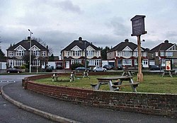
Turnford, Hertfordshire
| Turnford | |
|---|---|
 High Road, Turnford |
|
| Turnford shown within Hertfordshire | |
| Population | 8146 with Wormley |
| OS grid reference | TL3639204404 |
| District | |
| Shire county | |
| Region | |
| Country | England |
| Sovereign state | United Kingdom |
| Post town | Broxbourne |
| Postcode district | EN10 |
| Dialling code | 01992 |
| Police | Hertfordshire |
| Fire | Hertfordshire |
| Ambulance | East of England |
| EU Parliament | East of England |
| UK Parliament | |
Turnford is a village in the Borough of Broxbourne, in Hertfordshire, England, in an area generally known as the Lee Valley. It is bounded by Wormley to the north, Cheshunt to the south and west, and its eastern boundary is formed largely by the Lee Navigation. Central London at Charing Cross is approximately 18 miles (29 km) south. At the 2001 census, together with Wormley, the village had a population of 8,146 in 3,399 households.
Turnford lies in a site where evidence of Palaeolithic, Late Bronze Age and Iron Age relics have been recorded. By the late Saxon period the village existed as a farm belonging to the manor of Cheshunt. A Benedictine nunnery was established in the 12th century on Turnford Marsh. Part of the medieval buildings survived within a farm until gravel quarrying destroyed the remains in 1955. Turnford remained a hamlet up to the 19th century until the nursery industry began to move out of North London in the 1880s. Growers including Thomas Rochford grew grapes, tomatoes, cucumbers and other items. By the late 20th century this industry had moved away to be replaced by housing estates where Thomas Rochford Way and Rochford Close are a reminder of the area's horticultural past.
...
Wikipedia

