Broxbourne (UK Parliament constituency)
| Broxbourne | |
|---|---|
| Former Borough constituency for the House of Commons |
|

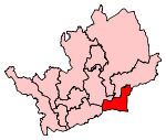
Boundary of Broxbourne in Hertfordshire.
|
|

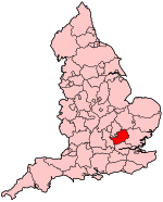
Location of Hertfordshire within England.
|
|
| County | Hertfordshire |
| Population | 98,790 (2011 census) |
| Electorate | 71,872 (December 2010) |
| Major settlements | Broxbourne |
| 1983–2016 | |
| Number of members | One |
| Created from |
Hertfordshire East Welwyn and Hatfield Hertford and Stevenage |
| European Parliament constituency | East of England |
Broxbourne is a constituency represented in the House of Commons of the UK Parliament since 2005 by Charles Walker of the Conservative Party.
1983-1997: The Borough of Broxbourne, the District of East Hertfordshire wards of Great Amwell, Little Amwell, and Stanstead, and the District of Welwyn Hatfield ward of Northaw.
1997–present: The Borough of Broxbourne, and the District of Welwyn Hatfield ward of Northaw.
The constituency was created in 1983 from the former seat of East Hertfordshire.
Broxbourne is, on the winning candidate's share of the vote, the safest seat for any Conservative in Hertfordshire and one of the safest in the country.
Just beyond the outer limits of Greater London, the seat consists almost exclusively of low unemployment census output areas, with walks, golf courses and leisure facilities and a relatively high proportion compared to Greater London of the retired and high-income self-employed, Broxbourne's economy is also supported by good links to the City of London by train.
Coordinates: 51°43′40″N 0°04′00″W / 51.72778°N 0.06667°W
...
Wikipedia
