Tupper Lake (village), New York
| Tupper Lake, New York | |
|---|---|
| Village | |

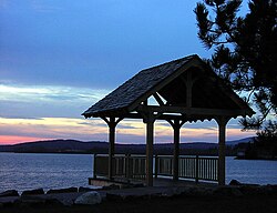
Raquette Pond
|
|
| Location within the state of New York | |
| Coordinates: 44°14′0″N 74°27′57″W / 44.23333°N 74.46583°WCoordinates: 44°14′0″N 74°27′57″W / 44.23333°N 74.46583°W | |
| Country | United States |
| State | New York |
| County | Franklin |
| Town | Tupper Lake |
| Area | |
| • Total | 2.1 sq mi (5.5 km2) |
| • Land | 2.1 sq mi (5.4 km2) |
| • Water | 0.04 sq mi (0.1 km2) |
| Elevation | 1,545 ft (471 m) |
| Population (2010) | |
| • Total | 3,667 |
| • Density | 1,754/sq mi (677.3/km2) |
| Time zone | Eastern (EST) (UTC-5) |
| • Summer (DST) | EDT (UTC-4) |
| ZIP code | 12986 |
| Area code(s) | 518 Exchange: 359 |
| FIPS code | 36-75671 |
| GNIS feature ID | 977539 |
| Website | www |
Tupper Lake is a village in Franklin County, New York, United States. The population was 3,667 at the 2010 census. The village is located within the boundaries of the Adirondack Park, west of Lake Placid. Along with nearby Saranac Lake, these three villages make up what is known as the Tri-Lakes region.
The village of Tupper Lake is in the town of Tupper Lake. The town and the village are in the southwest part of the county.
Tupper Lake is home to The Wild Center, a 54,000 square feet (5,000 m2) natural history center on a 31 acres (130,000 m2) campus.
Settlement began around 1844. The village was settled during the town's lumber production period and grew after it gained railroad service. The early village was composed of two parts, Tupper Lake proper and Faust. The town for a time held the distinction as the top lumber producer in the state.
The great fire of 1899 burned more than 169 structures in the village, two-thirds of them homes. The modern village grew out of this destruction and added all the amenities of a modern community earlier than many other villages in the state. Tupper had its own department store and synagogue, and its sprawling railway yards, driven by the lumber trade, made it a hub for the surrounding Adirondack communities.
The village of Tupper Lake is located near the center of the town of Tupper Lake at 44°14′00″N 74°27′57″W / 44.233210°N 74.465720°W, on the east shore of Raquette Pond, the northern end of the Tupper Lake water body. According to the United States Census Bureau, the village has a total area of 2.1 square miles (5.5 km2), of which 2.1 square miles (5.4 km2) is land and 0.04 square miles (0.1 km2), or 2.06%, is water.
...
Wikipedia

