Tull, Arkansas
| Tull, Arkansas | |
|---|---|
| Town | |
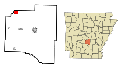
 Location in Grant County and the state of Arkansas |
|
| Coordinates: 34°26′47″N 92°34′53″W / 34.44639°N 92.58139°WCoordinates: 34°26′47″N 92°34′53″W / 34.44639°N 92.58139°W | |
| Country | United States |
| State | Arkansas |
| County | Grant |
| Area | |
| • Total | 3.43 sq mi (8.88 km2) |
| • Land | 3.42 sq mi (8.85 km2) |
| • Water | 0.02 sq mi (0.04 km2) |
| Elevation | 351 ft (107 m) |
| Population (2010) | |
| • Total | 448 |
| • Density | 131/sq mi (50.6/km2) |
| Time zone | Central (CST) (UTC-6) |
| • Summer (DST) | CDT (UTC-5) |
| FIPS code | 05-70220 |
| GNIS feature ID | 0055693 |
Tull is a town in Grant County, Arkansas, United States. The population was 448 at the 2010 census, up from 358 at the 2000 census. It is part of the Little Rock–North Little Rock–Conway Metropolitan Statistical Area.
Tull is located in northwestern Grant County at 34°26′47″N 92°34′53″W / 34.44639°N 92.58139°W (34.446405, -92.581518). It is bordered to the north and northwest by the Saline County line. The northwest border of the town follows the Saline River, a south-flowing tributary of the Ouachita River. Tull is 16 miles (26 km) northwest of Sheridan, the Grant County seat, and 10 miles (16 km) south of Benton.
According to the United States Census Bureau, the town has a total area of 3.4 square miles (8.9 km2), of which 0.02 square miles (0.04 km2), or 0.40%, is water.
As of the census of 2000, there were 358 people, 155 households, and 110 families residing in the town. The population density was 40.4/km² (104.6/mi²). There were 167 housing units at an average density of 18.9/km² (48.8/mi²). The racial makeup of the town was 99.16% White, 0.56% Native American, and 0.28% from two or more races. 3.07% of the population were Hispanic or Latino of any race.
...
Wikipedia
