Tuguegarao
| Tuguegarao | ||
|---|---|---|
| Component City | ||
 |
||
|
||
| Nickname(s): The Country's Premier Ibanag City; Heat City of the Philippines | ||
 Location in the province of Cagayan |
||
| Location within the Philippines | ||
| Coordinates: 17°37′N 121°43′E / 17.617°N 121.717°ECoordinates: 17°37′N 121°43′E / 17.617°N 121.717°E | ||
| Country | Philippines | |
| Region | Cagayan Valley (Region II) | |
| Province | Cagayan | |
| Congr. district | 3rd District of Cagayan | |
| Township | May 9, 1604 | |
| Patronal Feast Day | August 17 | |
| Cityhood | December 18, 1999 | |
| Barangays | 49 | |
| Government | ||
| • Type | Mayor–council | |
| • Mayor | Jefferson P. Soriano | |
| • Vice-Mayor | Bienvenido De Guzman II | |
| • City Council |
Councilors
|
|
| Area | ||
| • Total | 144.80 km2 (55.91 sq mi) | |
| Population (2015) | ||
| • Total | 153,502 | |
| • Density | 1,100/km2 (2,700/sq mi) | |
| Demonym(s) | Tuguegaraoeño (masculine) Tuguegararoeña (feminine) |
|
| Time zone | PST (UTC+8) | |
| ZIP code | 3500 | |
| Dialing code | 78 | |
| Income class | 3rd class (CYs 2004-2007) | |
| Website | www |
|
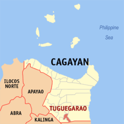
Tuguegarao, (Ibanag: Siudad nat Tuguegarao; Ilocano: Ciudad ti Tuguegarao; Filipino: Lungsod ng Tuguegarao) is a 3rd-class (CYs 2004-2007) component city in the Philippines. It is the capital of the province of Cagayan and the regional and institutional center of Cagayan Valley Region.
The city, on the southern border of the province, is located where the Pinacanauan River empties into the Cagayan River and is surrounded by the Sierra Madre Mountains to the east, Cordillera Mountains to the west, and the Caraballo Mountains to the south.
The population of the city as of the 2015 census is 153,502 people. Most of the inhabitants are Ilocanos, Ibanags and Itawes. Some are of Chinese and Indian descent.
The highest temperature ever recorded in the Philippines -- 42.2 °C (108.0 °F)—was recorded in Tuguegarao on April 29, 1912 and again on May 11, 1969. Average temperature during March and April is 38 °C (100 °F), one of the highest in the country.
The city is politically subdivided into 49 barangays. 31 of these barangays have been classified by the city as urban. Most of the rural barangays have agricultural territories, although some of the urbanized ones have mixed commercial, residential, and agricultural sites.
There are several versions of legends looming about the origin of the name of the city of Tuguegarao. One is the abundance of "tarrao" trees in the area. Another is from the word "tuggi" meaning fire. Another recorded version is, the town was formerly called Tuerao by the people of the northern towns. Still another is that the name Tuguegarao comes from two Ibanag words "tuggi" (fire) and "aggao" (day), possibly referring to a daytime fire that happened in the town. The most accepted version of the legend is the Ibanags' reply to the Spaniards when the latter asked for the name of the place - "Tuggi gari yaw", meaning "This used to be fire", or the town was carved out of the wilderness by clearing and burning. On the other hand, a historical evidence that might provide clues to the origin of the city's name comes from the fact that in 1591, the place was listed as a Spanish encomienda (land grant), which was originally a pre-colonial settlement called Tubigarao.
...
Wikipedia


