Tug Hill
| Tug Hill | |
| Region | |
|
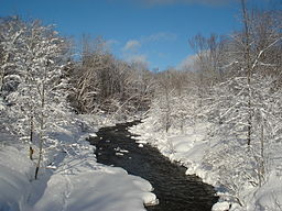
View of the North Branch of the Salmon River after a fresh snowfall, north of Redfield, in the Tug Hill region of New York.
|
|
| Country | United States |
|---|---|
| State | New York |
| Region | Tug Hill |
| Area | 2,100 sq mi (5,439 km2) |
| Population | Approx. 100,000 |
| Timezone | Eastern Standard Time (UTC-5) |
| - summer (DST) | Eastern Daylight Time (UTC-4) |
| Area code | 315 |
|
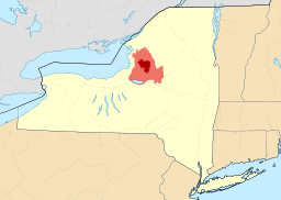
Map of New York State showing the greater Tug Hill region (light red), and its heavily forested "core" region (dark red). Core area based upon The Nature Conservancy's 150,000-acre (610 km2) delineation.
|
|
|
Area and population are given for the greater Tug Hill region as defined by NYS Law. The core Tug Hill area, covering at most 800 square miles (2,100 km2) within the larger legal region, is sparsely populated, containing just a few thousand full-time residents.
|
|
Tug Hill, sometimes referred to as the Tug Hill Plateau, is an upland region in Upstate New York in the United States, famous for heavy winter snows. The Tug Hill region is east of Lake Ontario, north of Oneida Lake, and west of the Adirondack Mountains. The region is separated from the Adirondacks by the Black River Valley.
Although the region has traditionally been known as the Tug Hill plateau because its top is flat, it is actually not a plateau, but rather a cuesta, since it is actually composed of sedimentary rocks that tip up on one side, rising from about 350 feet (110 m) on the west to over 2,000 feet (610 m) in the east.
It covers portions of four Upstate New York counties: Jefferson, Lewis, Oneida, and Oswego.
The Tug Hill region comprises an expansive ring of rural and agricultural outlying areas surrounding a sparsely-populated "core" region. The majority of the region's population is concentrated in villages that are situated primarily at the region's outer edge.
The greater Tug Hill region is defined in New York State law as encompassing the following 41 towns in four counties, with a total area of approximately 2,100 square miles (5,400 km2):
Within the greater Tug Hill area lies the "core" Tug Hill region, defined not by municipal boundaries but rather by its continuous forests, minimal roads and sparse population. The stated size of the Tug Hill's core varies by source, but generally ranges from 235 square miles (610 km2) to 800 square miles (2,100 km2).
...
Wikipedia


