Black River (New York)
| Black River | |
|
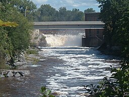
The Black River's Great Falls, Watertown, New York.
|
|
| Country | United States |
|---|---|
| State | New York |
| Tributaries | |
| - left | South Branch Black River, Deer River |
| - right |
Moose River Otter Creek, Independence River, Beaver River |
| Source | North Lake |
| - location | Herkimer County, New York, Adirondack Mountains |
| - elevation | 1,850 ft (564 m) |
| - coordinates | 43°31′19″N 74°56′53″W / 43.52194°N 74.94806°W |
| Mouth | Lake Ontario |
| - location | Dexter, Jefferson County |
| - elevation | 246 ft (75 m) |
| - coordinates | 43°59′39″N 76°03′54″W / 43.99417°N 76.06500°WCoordinates: 43°59′39″N 76°03′54″W / 43.99417°N 76.06500°W |
| Length | 125 mi (201 km) |
| Basin | 1,920 sq mi (4,973 km2) |
| Discharge | for Watertown |
| - average | 4,242 cu ft/s (120 m3/s) |
| - max | 52,000 cu ft/s (1,472 m3/s) |
| - min | 137 cu ft/s (4 m3/s) |
|
A map of the Black River watershed
|
|
The Black River is a 125-mile-long (201 km)blackwater river that empties into the eastern end of Lake Ontario on the shore of Jefferson County, New York in the United States. The origin of the name is not clear, but it may stem from the natural tannic acid that darkens the water in places. The river flows in a generally northwest direction, with its valley dividing the Adirondack Mountains on the east from the Tug Hill region to the west.
Right
Otter Brook
Indian Creek
Cold Brook
Cummings Creek
Mile Creek
Fall Brook
Miller Brook
Cold Brook
Moose River
Fish Creek
Otter Creek
Independence River
Harvey Creek
Hodge Creek
Crystal Creek
Capidon Creek
Beaver River
Potash Creek
Swiss Creek
Kelsey Creek
Philomel Creek
Trout Creek
...
Wikipedia


