Tubac
| Tubac, Arizona | |
|---|---|
| Census-designated place | |

St. Ann's Church, Tubac, 1937
|
|
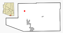
 Location in Santa Cruz County and the state of Arizona |
|
 18th century map of Tubac and surroundings |
|
| Coordinates: 31°37′32″N 111°3′7″W / 31.62556°N 111.05194°WCoordinates: 31°37′32″N 111°3′7″W / 31.62556°N 111.05194°W | |
| Country | United States |
| State | Arizona |
| County | Santa Cruz |
| Area | |
| • Total | 10.8 sq mi (28.0 km2) |
| • Land | 10.8 sq mi (28.0 km2) |
| • Water | 0.0 sq mi (0.0 km2) |
| Elevation | 3,209 ft (978 m) |
| Population (2010) | |
| • Total | 1,191 |
| • Density | 110/sq mi (43/km2) |
| Time zone | MST (no DST) (UTC-7) |
| ZIP codes | 85640, 85646 |
| Area code(s) | 520 |
| FIPS code | 04-75940 |
| GNIS feature ID | 0035489 |
Tubac is a census-designated place (CDP) in Santa Cruz County, Arizona, United States. The population was 1,191 at the 2010 census. The place name "Tubac" is an English borrowing from a Hispanicized form of the O'odham name, which translates into English as "rotten". The original O'odham name is written Cuwak. The first syllable is accented. When first taken into Spanish speech, it was spelled Tubaca. Finally over time the last "a" was dropped. Tubac is situated on the Santa Cruz River.
Tubac was the original Spanish colonial garrison in Arizona. It was depopulated during the O'odham Uprising in the 18th century. During the 19th century, the area was repopulated by miners, farmers and ranchers, but the town of Tubac is best known today as an artists' colony.
Tubac is located at 31°37′32″N 111°3′7″W / 31.62556°N 111.05194°W (31.625462, -111.051921).
According to the United States Census Bureau, the CDP has a total area of 10.8 square miles (28.0 km2), all land.
Established in 1752 as a Spanish presidio, the first Spanish colonial garrison in what is now Arizona, Tubac was one of the stops on the Camino Real (the "Royal Road") from Mexico to the Spanish settlements in California.
...
Wikipedia
