Truxton, New York
| Truxton, New York | |
|---|---|
| Town | |

Main St. (Rt. 13)
|
|
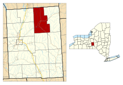
 Location within Cortland County and New York |
|
| Location in the United States | |
| Coordinates: 42°42′33″N 76°1′25″W / 42.70917°N 76.02361°W | |
| Country | United States |
| State | New York |
| County | Cortland |
| Government | |
| • Type | Town Council |
| • Town Supervisor | Frank O'Donnell |
| • Town Council |
Members' List
|
| Area | |
| • Total | 44.7 sq mi (115.8 km2) |
| • Land | 44.6 sq mi (115.6 km2) |
| • Water | 0.08 sq mi (0.2 km2) |
| Elevation | 1,142 ft (348 m) |
| Population (2010) | |
| • Total | 1,133 |
| • Density | 25/sq mi (9.8/km2) |
| Time zone | Eastern (EST) (UTC-5) |
| • Summer (DST) | EDT (UTC-4) |
| ZIP codes | 13056, 13158 |
| Area code(s) | 607 |
| FIPS code | 36-75550 |
| GNIS feature ID | 0979560 |
| Website | www |
Truxton is a town in Cortland County, New York, United States. The population was 1,133 at the 2010 census. The town is named for Commodore Thomas Truxtun, a privateer in the American Revolution and one of the US Navy's first commanding officers.
Truxton is in the northeast part of the county, northeast of Cortland.
The region was in the Central New York Military Tract.
The first settler arrived around 1793. The town was formed from part of the town of Fabius (in Onondaga County) when Cortland County was created in 1808. An addition was made in 1811 to Truxton from the town of Solon. In 1858, part of Truxton was used to form the town of Cuyler.
In 1865, the population was 1,689.
The Truxton Depot was listed on the National Register of Historic Places in 2008.
According to the United States Census Bureau, the town has a total area of 44.7 square miles (115.8 km2), of which 44.6 square miles (115.6 km2) is land and 0.077 square miles (0.2 km2), or 0.17%, is water.
The north town line is the border of Onondaga County.
The East Branch of the Tioughnioga River passes through the town.
New York State Route 13 intersects New York State Route 91 at Truxton village.
...
Wikipedia


