Troy, AL
| Troy, Alabama | ||
|---|---|---|
| City | ||

View of the western side of the downtown square in Troy
|
||
|
||
| Motto: "A Wonderful Place to Live!" | ||
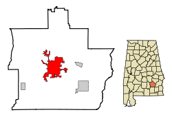
 Location within Pike County (left) and Alabama (right) |
||
| Location in the United States | ||
| Coordinates: 31°48′32″N 85°58′12″W / 31.80889°N 85.97000°WCoordinates: 31°48′32″N 85°58′12″W / 31.80889°N 85.97000°W | ||
| Country | United States | |
| State | Alabama | |
| County | Pike | |
| Founded | 1838 | |
| Incorporated | 1843 | |
| Government | ||
| • Type | Mayor-Council | |
| • Mayor | Jason Reeves | |
| Area | ||
| • Total | 28.30 sq mi (73.28 km2) | |
| • Land | 28.22 sq mi (73.08 km2) | |
| • Water | 0.08 sq mi (0.20 km2) | |
| Elevation | 541 ft (165 m) | |
| Population (2010) | ||
| • Total | 18,033 | |
| • Estimate (2016) | 19,191 | |
| • Density | 678.25/sq mi (261.87/km2) | |
| Time zone | CST (UTC-6) | |
| • Summer (DST) | CDT (UTC-5) | |
| ZIP codes | 36079, 36081, 36082 | |
| Area code | 334 Exchanges: 566,670,807,808 | |
| FIPS code | 01-76920 | |
| GNIS feature ID | 0153725 | |
| Website | www |
|
Troy is a city in Pike County, Alabama, United States. The city is the county seat of Pike County. It was formally incorporated on February 4, 1843.
As of the 2010 census, the population was 18,033. The 2015 estimated population was 18,696. The City of Troy is considered one of the fastest growing cities in Alabama. Troy is a college town and is home to Troy University, the second-largest university in total enrollment in the state of Alabama.
Once part of territory belonging to the Creek Indian, the land that would later become Troy was settled in the early 1830s. Originally known as Deer Stand Hill (an Indian hunting ground) and first settled about 1824, it was later known as Zebulon and then Centreville before being renamed Troy (1838). Troy burned down in 1901 and had to be rebuilt from scratch.
Troy became the county seat in 1838 after being moved from Monticello. A hotel and taverns along with small mercantile stores were soon created, quickly making the new town the social center of the county.
To promote movement of settlers and to speed mail from Washington City to New Orleans, the Federal Road was laid out after 1805. In 1824, a military road was laid out from Fort Barrancas in Pensacola, Florida and ran on top of the ridges to Fort Mitchell in Russell County, Alabama, and connected to The Federal Road. Captain Daniel E. Burch of the U.S. Army marked the route using three notches on trees for a crew under Lt. Elias Phillips to follow. The route was eventually cleared in 1824 at a cost of $1,130. It follows the ridge dividing the water sheds of the Conecuh River to the northwest, and the Yellow and Pea Rivers to the southeast. This road became known as The Three Notch Road and ran through Troy and Pike County. While never being highly needed as a military supply road, it became a boon to the settlers who used it to move into south-central and southeast Alabama and into northwest Florida.
Battle at Hobdy's Bridge
The Battle of Hobdy’s Bridge took place in February 1837 on a wooden bridge that spanned the river between Pike and Barbour counties and involved about 100 settlers and 75 Native American warriors. The Battle of Hobdy’s Bridge lasted less than 30 minutes and produced few casualties.
Battle at Pea River Pea Creek
...
Wikipedia


