Pike County, Alabama
| Pike County, Alabama | |
|---|---|

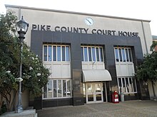
Pike County Courthouse in Troy
|
|
 Location in the U.S. state of Alabama |
|
 Alabama's location in the U.S. |
|
| Founded | December 17, 1821 |
| Named for | Zebulon Pike |
| Seat | Troy |
| Largest city | Troy |
| Area | |
| • Total | 673 sq mi (1,743 km2) |
| • Land | 672 sq mi (1,740 km2) |
| • Water | 0.9 sq mi (2 km2), 0.1% |
| Population (est.) | |
| • (2015) | 33,046 |
| • Density | 49/sq mi (19/km²) |
| Congressional district | 2nd |
| Time zone | Central: UTC-6/-5 |
| Website | www |
|
Footnotes:
|
|
Footnotes:
Pike County is a county of the U.S. state of Alabama. As of the 2010 census the population was 32,899. Its county seat is Troy. Its name is in honor of General Zebulon Pike, of New Jersey, an explorer who led an expedition to southern Colorado and discovered Pikes Peak in 1806.
Pike County comprises the Troy, AL Micropolitan Statistical Area.
Between the years of 1763 and 1783 the area that is now Pike County was part of the colony of British West Florida. After 1783 the region fell under the jurisdiction of the newly created United States of America. In 1819 the State of Alabama was admitted to the Union and was soon organized into counties. Named after General Zebulon Montgomery Pike of New Jersey, Pike County was one of the oldest in the state, organized on December 17, 1821. The temporary county seat was established at the house of Andrew Townsend. Pike County comprised a large tract of country, so large that it was called the State of Pike, including a part of what are now Crenshaw, Montgomery, Macon, Bullock, and Barbour counties, and extended to the Chattahoochie River on the east.
According to the U.S. Census Bureau, the county has a total area of 673 square miles (1,740 km2), of which 672 square miles (1,740 km2) is land and 0.9 square miles (2.3 km2) (0.1%) is water.
As of the census of 2000, there were 29,605 people, 11,933 households, and 7,649 families residing in the county. The population density was 44 people per square mile (17/km2). There were 13,981 housing units at an average density of 21 per square mile (8/km2). The racial makeup of the county was 60.77% White, 36.60% Black or African American, 0.66% Native American, 0.35% Asian, 0.02% Pacific Islander, 0.26% from other races, and 1.35% from two or more races. 1.23% of the population were Hispanic or Latino of any race.
...
Wikipedia
