Tropical Storm Marco (2008)
| Tropical storm (SSHWS/NWS) | |

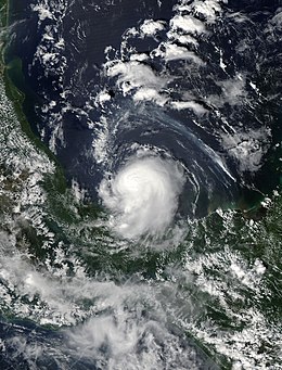
Tropical Storm Marco near peak intensity
|
|
| Formed | October 6, 2008 |
|---|---|
| Dissipated | October 7, 2008 |
| Highest winds |
1-minute sustained: 65 mph (100 km/h) |
| Lowest pressure | 998 mbar (hPa); 29.47 inHg |
| Fatalities | None reported |
| Damage | Minimal |
| Areas affected | Mexico |
| Part of the 2008 Atlantic hurricane season | |
Tropical Storm Marco is the smallest tropical cyclone on record. The thirteenth named storm of the 2008 Atlantic hurricane season, Marco developed out of a broad area of low pressure over the northwestern Caribbean during late September 2008. Influenced by a tropical wave on October 4, a small low-level circulation center developed over Belize. After crossing the southern end of the Yucatán Peninsula and emerging into the Bay of Campeche, the low was declared Tropical Depression Thirteen early on October 6. The depression quickly intensified into a tropical storm and was given the name Marco later that day. Marco reached its peak intensity with winds of 65 mph (100 km/h) early on October 7. Around this time, tropical storm force winds extended 11.5 miles (18.5 km) from the center of the storm, making Marco the smallest tropical cyclone on record. Around 1200 UTC, Marco made landfall near Misantla, Veracruz. The storm rapidly weakened after landfall, dissipating later that day. Due to its small size, Marco caused minimal damage; however, the storm's heavy rains led to floods up to 10 feet (3.05 m) deep that covered highways and damaged homes.
Tropical Storm Marco originated in a broad area of low pressure that persisted over the northwestern Caribbean in late September 2008. On October 4, a tropical wave reached the same area, and the system spawned a circulation center over Belize. Development of the low was initially inhibited by its proximity to land. As the system neared the Bay of Campeche, convection quickly developed around the low. At 0000 UTC on October 6, the low was designated as Tropical Depression Thirteen while located over Laguna de Términos. A mid-level ridge located to the north of the depression led to movement in a general west-northwest direction. Forecasters anticipated intensification up until landfall because of the storm's well-developed outflow and the low wind shear and high sea surface temperatures in its path. By 1200 UTC, the small cyclone, with a cloud shield no more than 85 miles (137 kilometers) across, was upgraded to Tropical Storm Marco.
...
Wikipedia
