Trindade and Martim Vaz

Rocky cliffs of Trindade Island
|
|
| Geography | |
|---|---|
| Location | Atlantic Ocean |
| Coordinates | 20°31′30″S 29°19′30″W / 20.52500°S 29.32500°WCoordinates: 20°31′30″S 29°19′30″W / 20.52500°S 29.32500°W |
| Archipelago | Arquipélago de Trindade e Martin Vaz |
| Total islands | 5 |
| Major islands | Trindade; Martin Vaz |
| Area | 10.4 km2 (4.0 sq mi) |
| Highest elevation | 620 m (2,030 ft) |
| Highest point | Pico do Desejado |
| Administration | |
| Region | Southeast |
| State | Espírito Santo |
| Administration | 1st Naval District of the Brazilian Navy |
| Demographics | |
| Population | 32 (2009) |
| Additional information | |
| Official website | Brazilian Navy First Naval District |
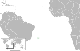
Trindade and Martin Vaz (Portuguese: Trindade e Martim Vaz, pronounced: [tɾĩˈdadʒi i mɐʁˈtʃĩ ˈvas]) is an archipelago located about 1,170 kilometres (730 miles) east of Vitória in the Southern Atlantic Ocean, belonging to the State of Espírito Santo, Southeast Brazil. The archipelago has a total area of 10.4 square kilometres (4.0 square miles) and a population of 32 (Brazilian Navy personnel). The archipelago consists of five islands and several rocks and stacks; Trindade is the largest island, with an area of 10.1 square kilometres (3.9 square miles); about 49 kilometres (30 miles) east of it are the tiny Martin Vaz islets, with a total area of 0.3 square kilometres (30.0 hectares) .
The islands are of volcanic origin and have rugged terrain. They are largely barren, except for the southern part of Trindade. They were discovered in 1502 by Portuguese explorer Estêvão da Gama and stayed Portuguese until they became part of Brazil at its independence. From 1895 to 1896, Trindade was occupied by the United Kingdom until an agreement with Brazil was reached. During the period of British occupation, Trindade was known as "South Trinidad."
The individual islands with their respective locations are given in the following:
The small island of Trindade, with an area of 10.3 km², lies at the eastern end of an E-W-trending chain of submarine volcanoes and guyots extending about 1,000 km (620 mi) from the continental shelf off the Brazilian coast. The island lies more than halfway between Brazil and the Mid-Atlantic Ridge near the eastern end of the submarine Vitória-Trindade Ridge.
...
Wikipedia

