Tricase
| Tricase | ||
|---|---|---|
| Comune | ||
| Comune di Tricase | ||

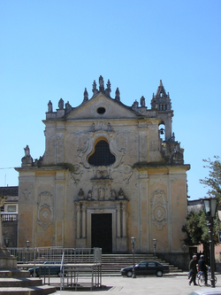
Dominican convent in Tricase.
|
||
|
||
| Location of Tricase in Italy | ||
| Coordinates: 39°56′N 18°22′E / 39.933°N 18.367°ECoordinates: 39°56′N 18°22′E / 39.933°N 18.367°E | ||
| Country | Italy | |
| Region | Apulia | |
| Province / Metropolitan city | Lecce (LE) | |
| Frazioni | Depressa, Lucugnano, Tutino, Caprarica, Sant'Eufemia, Tricase porto, Marina serra | |
| Government | ||
| • Mayor | Antonio Giuseppe Coppola | |
| Area | ||
| • Total | 43.64 km2 (16.85 sq mi) | |
| Elevation | 98 m (322 ft) | |
| Population (31 December 2004) | ||
| • Total | 17,870 | |
| • Density | 410/km2 (1,100/sq mi) | |
| Demonym(s) | Tricasini | |
| Time zone | CET (UTC+1) | |
| • Summer (DST) | CEST (UTC+2) | |
| Postal code | 73039, 73030 the frazioni | |
| Dialing code | 0833 | |
| Patron saint | San Vito | |
| Saint day | 15 June | |
| Website | Official website | |
Tricase is a town and comune in the province of Lecce, part of the Apulia region of south-east Italy. It is located in the Salento traditional region.
Tricase is the site of a castle and of a Quercia Vallonea, an oak which is amongst the oldest trees in Italy, dating from the 13th century.
After World War II, a refugee camp was set up at Tricase, sometimes referred to as Tricase Porto or Tricasi displaced persons camp.
...
Wikipedia


