Tricarico
| Tricarico | ||
|---|---|---|
| Comune | ||
| Comune di Tricarico | ||

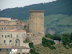
Norman tower and Monastery of Santa Chiara
|
||
|
||
| Location of Tricarico in Italy | ||
| Coordinates: 40°37′N 16°9′E / 40.617°N 16.150°E | ||
| Country | Italy | |
| Region | Basilicata | |
| Province / Metropolitan city | Matera (MT) | |
| Frazioni | Calle | |
| Government | ||
| • Mayor | Raffaello Marsilio | |
| Area | ||
| • Total | 176.91 km2 (68.31 sq mi) | |
| Elevation | 698 m (2,290 ft) | |
| Population (March 2009) | ||
| • Total | 5,920 | |
| • Density | 33/km2 (87/sq mi) | |
| Demonym(s) | Tricaricési | |
| Time zone | CET (UTC+1) | |
| • Summer (DST) | CEST (UTC+2) | |
| Postal code | 75019 | |
| Dialing code | 0835 | |
| Patron saint | St. Potitus | |
| Saint day | 14 January | |
| Website | Official website | |
Tricarico (Greek: Triakrikon) is a town and comune in the province of Matera, Basilicata, southern Italy.
It is home to one of the best preserved medieval historical centres in Lucania.
The origin of the name Tricarico is unknown. According to one hypothesis, it cound be Triacricon, deriving from the Greek words treis ("three") and acron/acra (an apex, either a "citadel", or just a "summit"), with Triacricon meaning the city "with the three citadels". These three acra/citadels were no other than the site of the 9th c Arabic castle of Saracena in the north, the site of a 9th-10th c Byzantine Rocca fortificata in the south, improved during the 11th-12th c by the Normans, and then, during the 13th c, by the Hohenstaufen, and also the site of the 14th c Palazzo Ducale in the middle. Probably the three sites were simultaneously fortified even before the successive occupations.
Although of ancient origin, the first news documented about the town dates to 849, when it was a Lombard county included in the gastaldate of Salerno. Later (9th century - late 10th century) it was an Arabic stronghold. The terrace gardens, of Arabic origin, are still in use today. In 968 Tricarico was conquered by the Byzantine Empire, and then, in 1048, it became a Norman fortified town.
...
Wikipedia


