Trevi (PG)
| Trevi | ||
|---|---|---|
| Comune | ||
| Comune di Trevi | ||
 |
||
|
||
| Location of Trevi in Italy | ||
| Coordinates: 42°53′N 12°45′E / 42.883°N 12.750°E | ||
| Country | Italy | |
| Region | Umbria | |
| Province / Metropolitan city | Perugia (PG) | |
| Frazioni | Borgo, Bovara, Cannaiola, Coste, Lapigge, Manciano, Matigge, Parrano, Picciche, San Lorenzo, Santa Maria in Valle | |
| Government | ||
| • Mayor | Bernardino Sperandio | |
| Area | ||
| • Total | 71.2 km2 (27.5 sq mi) | |
| Elevation | 412 m (1,352 ft) | |
| Population (2007) | ||
| • Total | 8,176 | |
| • Density | 110/km2 (300/sq mi) | |
| Demonym(s) | Trevani | |
| Time zone | CET (UTC+1) | |
| • Summer (DST) | CEST (UTC+2) | |
| Postal code | 06039 (hillside) and 06032 (valley) | |
| Dialing code | 0742 | |
| Patron saint | St. Emilian | |
| Saint day | January 28 | |
| Website | Official website | |
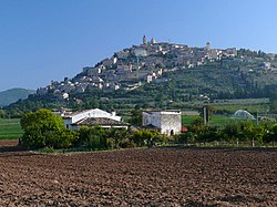
Trevi (Latin: Trebiae) is an ancient town and comune in Umbria, Italy, on the lower flank of Monte Serano overlooking the wide plain of the Clitunno river system. It is 10 km (6 mi) SSE of Foligno and 20 km (12 mi) north of Spoleto.
The population of the comune was c. 8,000 in 2004, with the town proper accounting for about half of that; the rest lives in the frazioni of Borgo, Bovara, Cannaiola, Coste, Pigge, Manciano, Matigge, Parrano, Picciche, San Lorenzo and Santa Maria in Valle. The historical subdivisions of Trevi proper are the terzieri of Castello, Matiggia e Piano; they come into play only for the Palio.
Most of the town, densely inhabited and of decidedly medieval aspect, lies on sharply sloping terrain, only the very center being more or less flat. It commands one of the best views in Umbria, extending over 50 km (30 mi) in most westerly directions. Trevi is served by the main rail line from Rome to Ancona as well as the line from Florence to Rome via Perugia.
The territory of the comune, extends over 71 sq. km from the valley (210 m) to Mts. Brunette (1422 m) and Serano (1429 m) and can be divided into three more or less equal zones: plain, hills, and mountain; each with its own characteristic vegetation. In the plain, the very fertile land is well irrigated by many watercourses, heirs for the most part to the "Lacus Clitorius" of Antiquity, and is suited to annual crops. The hills, of a very loose alkaline limestone with excellent drainage, are an ideal terrain for the intensive and highly specialized cultivation of olive trees, that produce a very characteristic and highly prized oil. Finally, the mountains are clothed in meadows and forests, primarily deciduous.
The natural environment of the territory as a whole remains largely unspoiled, this despite being significantly populated for millennia. The mountainous area is now witnessing a considerable depopulation — as elsewhere in Italy, in the second half of the 20th century settlements at the highest elevations have been rapidly losing their inhabitants to the plains. The most important growth areas since the period following World War II have been Borgo Trevi (commercial, residential and offices), Pietrarossa (industrial) and Matigge (light and medium industry, commercial).
...
Wikipedia


