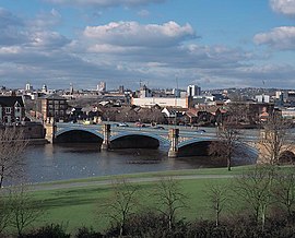
Trent Valley
| River Trent | |
|
Trent Bridge, with Nottingham in the background
|
|
| Country | United Kingdom |
|---|---|
| Country within the UK | England |
| Counties | Staffordshire, Derbyshire, Leicestershire, Nottinghamshire, Lincolnshire, Yorkshire |
| Cities | Stoke-on-Trent, Nottingham |
| Towns | Stone, Burton upon Trent, Newark-on-Trent, Gainsborough |
| Tributaries | |
| - left | Blithe, Swarbourn, Dove, Derwent, Erewash, Leen, Greet, Idle, Torne |
| - right | Sow, Tame, Mease, Soar, Devon, Eau |
| Source | |
| - location | Biddulph Moor, Staffordshire, England |
| - elevation | 275 m (902 ft) |
| - coordinates | 53°07′05″N 2°08′36″W / 53.118011°N 2.14332°W |
| Mouth | |
| - location | Trent Falls, Humber Estuary, Lincolnshire & Yorkshire, England |
| - elevation | 0 m (0 ft) |
| - coordinates | 53°42′03″N 0°41′28″W / 53.700833°N 0.691111°WCoordinates: 53°42′03″N 0°41′28″W / 53.700833°N 0.691111°W |
| Length | 298 km (185 mi) |
| Basin | 10,435 km2 (4,029 sq mi) |
| Discharge | for Colwick |
| - average | 84 m3/s (2,966 cu ft/s) |
| - max | 1,018 m3/s (35,950 cu ft/s) |
| - min | 15 m3/s (530 cu ft/s) |
| Discharge elsewhere (average) | |
| - North Muskham | 88 m3/s (3,108 cu ft/s) |
|
The drainage basin of the River Trent.
|
|
| Progression : River Trent — Humber — North Sea | |
The River Trent is the third-longest river in the United Kingdom. Its source is in Staffordshire on the southern edge of Biddulph Moor. It flows through and drains most of the metropolitan central and northern Midlands south and east of its source north of Stoke-on-Trent. The river is known for dramatic flooding after storms and spring snowmelt, which in past times often caused the river to change course.
The river passes through Stoke-on-Trent, Burton upon Trent and Nottingham before joining the River Ouse at Trent Falls to form the Humber Estuary, which empties into the North Sea between Hull in Yorkshire and Immingham in Lincolnshire.
The name "Trent" is from a Celtic word possibly meaning "strongly flooding". More specifically, the name may be a contraction of two Celtic words, tros ("over") and hynt ("way"). This may indeed indicate a river that is prone to flooding. However, a more likely explanation may be that it was considered to be a river that could be crossed principally by means of fords, i.e. the river flowed over major road routes. This may explain the presence of the Celtic element rid (c.f. Welsh rhyd, "ford") in various place names along the Trent, such as Hill Ridware, as well as the Old English‐derived ford. Another translation is given as "the trespasser", referring to the waters flooding over the land. According to Koch at the University of Wales, the name Trent derives from the Romano-British Trisantona, a Romano-British reflex of the combined Proto-Celtic elements *tri-sent(o)-on-ā- (through-path-augmentative-feminine-) ‘great thoroughfare’. A traditional but almost certainly wrong opinion is that of Izaak Walton, who states in The Compleat Angler (1653) that the Trent is "... so called from thirty kind of fishes that are found in it, or for that it receiveth thirty lesser rivers."
...
Wikipedia


