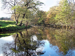
River Derwent, Derbyshire
| River Derwent | |
| River | |
|
The River Derwent, near Hathersage
|
|
| Country | England |
|---|---|
| Counties | Derbyshire |
| Tributaries | |
| - left | Bentley Brook, River Amber |
| - right | River Westend, River Ashop, River Noe, River Wye, River Ecclesbourne |
| Source | |
| - location | Bleaklow, east of Glossop |
| - coordinates | 53°28′01″N 1°48′47″W / 53.466894°N 1.813175°W |
| Mouth | |
| - location | Derwent Mouth, River Trent |
| - coordinates | 52°52′26″N 1°19′13″W / 52.8738°N 1.3203°WCoordinates: 52°52′26″N 1°19′13″W / 52.8738°N 1.3203°W |
| Length | 80 km (50 mi) |
| River Derwent | |||||||||||||||||||||||||||||||||||||||||||||||||||||||||||||||||||||||||||||||||||||||||||||||||||||||||||||||||||||||||||||||||||||||||||||||
|---|---|---|---|---|---|---|---|---|---|---|---|---|---|---|---|---|---|---|---|---|---|---|---|---|---|---|---|---|---|---|---|---|---|---|---|---|---|---|---|---|---|---|---|---|---|---|---|---|---|---|---|---|---|---|---|---|---|---|---|---|---|---|---|---|---|---|---|---|---|---|---|---|---|---|---|---|---|---|---|---|---|---|---|---|---|---|---|---|---|---|---|---|---|---|---|---|---|---|---|---|---|---|---|---|---|---|---|---|---|---|---|---|---|---|---|---|---|---|---|---|---|---|---|---|---|---|---|---|---|---|---|---|---|---|---|---|---|---|---|---|---|---|---|
|
|||||||||||||||||||||||||||||||||||||||||||||||||||||||||||||||||||||||||||||||||||||||||||||||||||||||||||||||||||||||||||||||||||||||||||||||
The Derwent is a river in Derbyshire, England. It is 66 miles (106 km) long and is a tributary of the River Trent, which it joins south of Derby. For half its course, the river flows through the Peak District.
Much of the river's route, with the exception of the city of Derby, is rural. However the river has also seen many human uses, and between Matlock and Derby was one of the cradles of the Industrial Revolution, providing power to the first industrial scale cotton mills. Today it provides a water supply to several surrounding cities, and its steeply sided valley is an important communications corridor through the uplands of the Peak District.
Because of its scenic qualities, the valley of the River Derwent sees many tourist visitors. The upper reaches pass through the Peak District National Park, whilst the middle reaches around the old spa town of Matlock Bath which attracts tourists because of its souvenir shops and amusement arcades, together with attractions such as the Heights of Abraham and its cable car.
Derwent is derived from Brittonic river name *Deruentiū, Latinised as Deruentiō, meaning "(Belonging/Pertaining to the) Forest of Oak Trees"; the old river name survived in medieval Welsh poetry, such as Pais Dinogad ("Dinogad's Smock") attached to the larger poem Y Gododdin, as Derwennydd.
The River Derwent rises at Swains Greave (590 metres above sea level) on the eastern flank of Bleaklow, opposite Howden Moors, and some 6 miles (9.7 km) east of Glossop. It flows through the Upper Derwent Valley, and for most of its first 6 miles (9.7 km) forms the county boundary between Derbyshire, on its west bank, and South Yorkshire, on the east bank. Some 4 miles (6.4 km) into its journey it reaches Howden Reservoir, the first of three consecutive such reservoirs, with Howden being followed by Derwent Reservoir and Ladybower Reservoir. The Derwent Reservoir is named after the now-submerged town of Derwent, which was named after the river. Once past Howden Reservoir, both banks of the river are in Derbyshire, and the river remains in the county to its mouth. Howden Reservoir is also fed by the River Westend, whilst Ladybower Reservoir is also fed by the River Ashop. In both cases the former confluences of the two tributaries with the River Derwent are now submerged below the respective reservoirs.
...
Wikipedia

