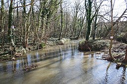
River Greet
| Greet | |
| River | |
|
The river downstream of Caudwell Mill, Southwell
|
|
| Country | England |
|---|---|
| County | Nottinghamshire |
| Source | |
| - location | Kirklington |
| Mouth | River Trent |
| - location | Fiskerton |
| - coordinates | 53°3′20″N 0°53′34″W / 53.05556°N 0.89278°WCoordinates: 53°3′20″N 0°53′34″W / 53.05556°N 0.89278°W |
The River Greet is a small river in Nottinghamshire, England. Rising close to the village of Kirklington, the Greet flows in a southeasterly direction past Southwell and Rolleston to meet the River Trent at Fiskerton.
The river has a catchment of 17.85 square miles (46.2 km2) and an average flow of 6.08 million gallons (27.65 Megalitres) per day, measured at the gauging station in Southwell. The catchment receives 25.47 inches (647 mm) of rainfall in an average year. Above Southwell, the underlying geology is mainly Sherwood and Mercia sandstone, with some Mercia mudstone along the southern edge of the catchment. Below Southwell, the geology is predominantly Mercia mudstone. There is a layer of clay, sand and gravel alluvium overlaying this in the river channel. The river is greatly affected by rainfall, raising levels and muddying the water.
The river rises as a series of springs to the west of Kirklington, close to the 160-foot (49 m) contour. It is joined by Cotton Mill Dyke and Edingley Beck, and to the east of Kirklington, turns to flow in a south-easterly direction. Halam Beck joins from the south, and there is a disused mill at Maythorne Farm. It was built as a cotton mill in 1795 by a hop merchant, to supply yarn to the framework knitting industry. The firm of Messrs. Bean and Johnson altered it in the early nineteenth century, after which silk and lace thread was produced. A small community was established around the mill, with cottages for some of the workers, of whom there were 70 in 1838, a general store, a public house and a mission hall. Willow for making baskets was grown in osier beds, and hops were also cultivated. The building was used as a billet for soldiers during the Second World War, by which time its industrial function had ceased. It has subsequently been converted into flats, with some of the outbuildings used as industrial workshops. There are two mill buildings, the north mill and the south mill, both of which are grade II listed structures. Below the mill the Robin Hood Way, a long distance footpath, follows the banks of the river, which forms the northern boundary of Southwell. There is a wildfowl centre on the north bank, and Caudwell flour Mill is on the south bank. It was built over the site of Burgage mill, a medieval building, and was bought by Charles Caudwell in 1851. He increased the capacity of the mill, which was subsequently damaged by fires in 1867, 1893 and 1917. Each time the mill was rebuilt, the equipment was upgraded. The Caudwell family were millers for four generations, after which Associated British Foods bought the mill. It closed in 1977, and was turned into flats in 1989.
...
Wikipedia

