Trans-Amazon Highway
| Trans-Amazonian Highway | |
|---|---|

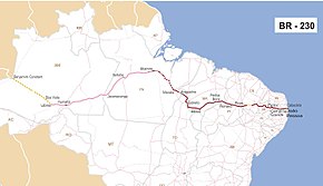
Map of BR-230 (paved portion shown in red)
|
|

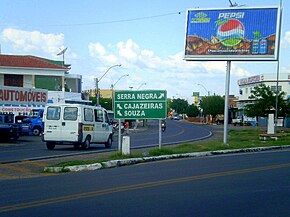
Trans-Amazonian highway within the city of Pombal, Paraíba.
|
|
| Highway system | |
|
Highways in Brazil |
The Trans-Amazonian Highway (official designation BR-230, official name Rodovia Transamazônica), was introduced on September 27, 1972. It is 4,000 km long, making it the third longest highway in Brazil. It runs through the Brazilian states of Paraíba, Ceará, Piaui, Maranhão, , Pará and Amazonas, from the proximities of Saboeiro up until the town of Lábrea.
The highway was intended to integrate these regions with the rest of the country, and with Colombia, Peru and Ecuador. Another main goal of the project was to alleviate the effects of the drought affecting the Northeast region of the country by providing a route to largely empty land in the middle of the rainforest, which could be settled. It was originally planned to be a fully paved highway 5200 kilometers long. However, these plans were modified following its inauguration.
In particular, because of high construction costs and Brazil financial crisis in the late 1970s, only a part of the highway was paved, from its beginning to 200 km ahead of Marabá. The lack of a fully sealed road caused many problems. Travel on the non-paved stretches of the highway is extremely difficult during the region's rainy season between October and March. In the wet season cars often get stuck in the poorly constructed road and in the dry season there are often pot holes in the dry mud roads that damage vehicles.
...
Wikipedia

