Trams in Nuremberg

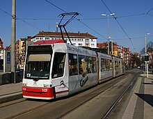
A GT6N tram in Friedrich-Ebert-Platz, 2012.
|
|||||||||||||||||||||||||
| Operation | |||||||||||||||||||||||||
|---|---|---|---|---|---|---|---|---|---|---|---|---|---|---|---|---|---|---|---|---|---|---|---|---|---|
| Locale | Nuremberg, Bavaria, Germany | ||||||||||||||||||||||||
|
|||||||||||||||||||||||||
|
|||||||||||||||||||||||||
The Nuremberg tramway network (German: Straßenbahnnetz Nürnberg) is a network of tramways forming part of the public transport system in Nuremberg, a city in the federal state of Bavaria, Germany.
The network is operated by VAG Verkehrs-Aktiengesellschaft Nürnberg (VAG), which is a member of the VGN (Verkehrsverbund Großraum Nürnberg or Greater Nuremberg Transport Network).
As of 2013[update], the network consisted of five lines, running on a total operational route length of 33 kilometres (21 mi). The network carried 39.152 million passengers annually.
The first horse-drawn tramline opened in Nuremberg on 25 August 1881.
Electrification came to the system when the first electric tramline opened on 7 May 1896. The entire system was electrified on 20 July 1898. Until the 1990s the track gauge was 1,432 mm (4 ft 8 3⁄8 in).
The Nuremberg tramway network operated on six lines until 2011, when two tram lines were joined.
The network is made up of 96 kilometres (60 mi) of track, with a total route length of 37 kilometres (23 mi), of which 33 kilometres (21 mi) is operational route. Of the tram's operational route, 41% is tramline segregated from other traffic, with the other 59% representing trams operating in the street with other automobile traffic.
The Nuremberg tramway network is made up of the following five lines:
After a 2016 ballot measure in Erlangen, the section to am Wegfeld is planned to be extended to Erlangen and from there to Herzogenaurach in a roughly L-shaped line. Herzogenaurach previously had a connection to mainline rail, but it was shut down in the 1980s, leaving it one of southern Germany's biggest cities without a rail connection.
Coordinates: 49°27′N 11°05′E / 49.450°N 11.083°E
...
Wikipedia

