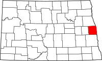
Traill County, North Dakota
| Traill County, North Dakota | |
|---|---|

|
|
 Location in the U.S. state of North Dakota |
|
 North Dakota's location in the U.S. |
|
| Founded | February 23, 1875 |
| Seat | Hillsboro |
| Largest city | Mayville |
| Area | |
| • Total | 863 sq mi (2,235 km2) |
| • Land | 862 sq mi (2,233 km2) |
| • Water | 0.6 sq mi (2 km2), 0.07% |
| Population (est.) | |
| • (2016) | 8,030 |
| • Density | 9.4/sq mi (4/km²) |
| Congressional district | At-large |
| Time zone | Central: UTC-6/-5 |
| Website | www |
Coordinates: 47°27′N 97°11′W / 47.450°N 97.183°W
Traill County is a county located in the U.S. state of North Dakota. As of the 2010 census listed the population at 8,121. Its county seat is Hillsboro, and its largest city is Mayville. The county was formed in 1875.
Traill County was created in 1875 by the 1874-75 territorial legislature. It was named after Walter John Strickland Traill, an employee of the Hudson's Bay Company and son of Canadian pioneer Catharine Parr Traill.
County headquarters were originally located in a small single-story building in Caledonia. Several replacement courthouses were built during the late 19th century and several votes to move the county seat to Mayville narrowly failed. Efforts to move the county seat to Hillsboro were more successful, and all county records were moved there in 1890. The current Traill County Courthouse started construction in 1905 and is listed in the National Register of Historic Places.
According to the U.S. Census Bureau, the county has a total area of 863 square miles (2,240 km2), of which 862 square miles (2,230 km2) is land and 0.6 square miles (1.6 km2) (0.07%) is water.
...
Wikipedia
