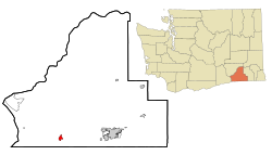
Touchet, Washington
| Touchet, Washington | |
|---|---|
| CDP | |
 |
|
 Location of Touchet, Washington |
|
| Coordinates: 46°2′22″N 118°40′15″W / 46.03944°N 118.67083°WCoordinates: 46°2′22″N 118°40′15″W / 46.03944°N 118.67083°W | |
| Country | United States |
| State | Washington |
| County | Walla Walla |
| Area | |
| • Total | 1.2 sq mi (3.1 km2) |
| • Land | 1.2 sq mi (3.1 km2) |
| • Water | 0.0 sq mi (0.0 km2) |
| Elevation | 443 ft (135 m) |
| Population (2010) | |
| • Total | 421 |
| • Density | 326.1/sq mi (125.9/km2) |
| Time zone | Pacific (PST) (UTC-8) |
| • Summer (DST) | PDT (UTC-7) |
| ZIP code | 99360 |
| Area code | 509 |
| FIPS code | 53-72030 |
| GNIS feature ID | 1509053 |
Touchet (/ˈtuːʃi/ TOO-shee) is a census-designated place (CDP) in Walla Walla County, Washington, United States. The population was 421 at the 2010 census.
The original inhabitants of the Walla Walla valley were the Nimi'ipuu people. These people, which originally included bands of Palouse, Yakamas, Umatilla, Walla Walla and Wanapum, were collectively renamed Nez Perce by Lewis and Clark when they passed through the Walla Walla Valley on their return journey in 1806.
Settlers from the east came to the valley in the early 1850s, but shortly left due to conflicts with the Native people. Homesteaders returned to the valley in 1859.
The Walla Walla & Columbia River Railroad from Wallula to Walla Walla was not completed until 1875, but by March 1874, 16 miles of track were completed up to Touchet. By the end of that year Touchet farmers shipped 4,000 tons of wheat and received 1,100 tons of merchandise.
Touchet has never been officially incorporated.
Touchet is located at 46°2′22″N 118°40′15″W / 46.03944°N 118.67083°W (46.039402, -118.670971).
...
Wikipedia
