Toropets
| Toropets (English) Торопец (Russian) |
|
|---|---|
| - Town - | |
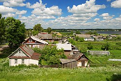
 View of Toropets |
|
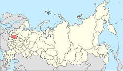
 Location of Tver Oblast in Russia |
|
|
|
|
|
|
|
|
|
|
| Administrative status (as of December 2012) | |
| Country | Russia |
| Federal subject | Tver Oblast |
| Administrative district | Toropetsky District |
| Urban settlement | Toropets |
| Administrative center of | Toropetsky District, Toropets Urban Settlement |
| Municipal status (as of March 2013) | |
| Municipal district | Toropetsky Municipal District |
| Urban settlement | Toropets Urban Settlement |
| Administrative center of | Toropetsky Municipal District, Toropets Urban Settlement |
| Statistics | |
| Population (2010 Census) | 13,015 inhabitants |
| Time zone | MSK (UTC+03:00) |
| First mentioned | 1074 |
| Postal code(s) | 172840, 172842, 172899 |
| on | |
Toropets (Russian: Торо́пец) is a town and the administrative center of Toropetsky District in Tver Oblast, Russia, located where the Toropa River enters Lake Solomennoye. Population: 13,015 (2010 Census);14,600 (2002 Census);17,510 (1989 Census).
Principality of Smolensk 1074–1167
Principality of Toropets 1167–ca. 1362![]() Grand Duchy of Lithuania ca. 1362–1386
Grand Duchy of Lithuania ca. 1362–1386![]() Poland-Lithuania 1386–1503
Poland-Lithuania 1386–1503![]() Grand Duchy of Moscow 1503–1547
Grand Duchy of Moscow 1503–1547![]() Tsardom of Russia 1547–1721
Tsardom of Russia 1547–1721![]() Russian Empire 1721–1917
Russian Empire 1721–1917![]() Russian Republic 1917
Russian Republic 1917![]() Soviet Russia 1917–1922
Soviet Russia 1917–1922![]() Soviet Union 1922–1991
Soviet Union 1922–1991![]() Russian Federation 1991–present
Russian Federation 1991–present
...
Wikipedia


